
File:Val Verde satellite image from 2014.png

Size of this preview: 800 × 530 pixels. Other resolutions: 320 × 212 pixels | 640 × 424 pixels | 946 × 627 pixels.
Original file (946 × 627 pixels, file size: 1.04 MB, MIME type: image/png)
| This is a file from the Wikimedia Commons. Information from its description page there is shown below. Commons is a freely licensed media file repository. You can help. |
Summary
| Description |
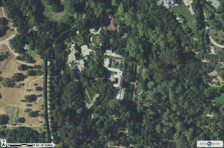
English: This picture, taken from the USDA NAIP 2014 dataset, shows a portion of the Val Verde Estate in Montecito, CA. |
| Date | |
| Source | https://map.dfg.ca.gov/arcgis/rest/services/Base_Remote_Sensing/NAIP_2014/ImageServer |
| Author | National Agriculture Imagery Program - USDA |
Licensing
| This file is made available under the Creative Commons CC0 1.0 Universal Public Domain Dedication. | |
| The person who associated a work with this deed has dedicated the work to the public domain by waiving all of their rights to the work worldwide under copyright law, including all related and neighboring rights, to the extent allowed by law. You can copy, modify, distribute and perform the work, even for commercial purposes, all without asking permission.
|
File history
Click on a date/time to view the file as it appeared at that time.
| Date/Time | Thumbnail | Dimensions | User | Comment | |
|---|---|---|---|---|---|
| current | 23:02, 17 January 2022 | | 946 × 627 (1.04 MB) | Raleighlittles | Uploaded a work by National Agriculture Imagery Program - USDA from https://map.dfg.ca.gov/arcgis/rest/services/Base_Remote_Sensing/NAIP_2014/ImageServer with UploadWizard |
File usage
The following pages on the English Wikipedia use this file (pages on other projects are not listed):