
File:Ustyurt Plateau.png
No higher resolution available.
Ustyurt_Plateau.png (613 × 460 pixels, file size: 514 KB, MIME type: image/png)
| This is a file from the Wikimedia Commons. Information from its description page there is shown below. Commons is a freely licensed media file repository. You can help. |
Summary
| Description |
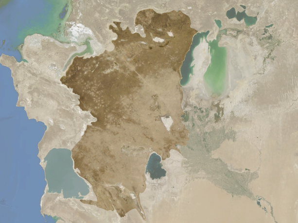
Français : Le plateau d'Oust-Ourt en surbrillance entre les mers Caspienne et d'Aral, entre le Kazakhstan, l'Ouzbékistan et le Kirghizistan. English: Ustyurt Plateau highlighted between Caspian and Aral seas in Kazakhstan, Uzbekistan and Kyrgyzstan. |
| Date | |
| Source | Cropped and colorised version of File:Kyzyl Kum.png |
| Author | NASA World Wind |
| Other versions | File:Kyzyl Kum.png |
| Camera location | | View this and other nearby images on: OpenStreetMap |
|---|
Licensing
| This image is in the public domain because it is a screenshot from NASA’s globe software World Wind using a public domain layer, such as Blue Marble, MODIS, Landsat, SRTM, USGS or GLOBE.
|
 |
File history
Click on a date/time to view the file as it appeared at that time.
| Date/Time | Thumbnail | Dimensions | User | Comment | |
|---|---|---|---|---|---|
| current | 14:15, 14 October 2012 | | 613 × 460 (514 KB) | Rémih | User created page with UploadWizard |
File usage
The following pages on the English Wikipedia use this file (pages on other projects are not listed):
Global file usage
The following other wikis use this file:
- Usage on ar.wikipedia.org
- Usage on az.wikipedia.org
- Usage on be.wikipedia.org
- Usage on bg.wikipedia.org
- Usage on ca.wikipedia.org
- Usage on ceb.wikipedia.org
- Usage on es.wikipedia.org
- Usage on eu.wikipedia.org
- Usage on fa.wikipedia.org
- Usage on fr.wikipedia.org
- Usage on he.wikipedia.org
- Usage on hr.wikipedia.org
- Usage on hu.wikipedia.org
- Usage on id.wikipedia.org
- Usage on it.wikipedia.org
- Usage on kk.wikipedia.org
- Usage on ko.wikipedia.org
- Usage on ky.wikipedia.org
- Usage on lt.wikipedia.org
- Usage on mt.wikipedia.org
- Usage on pl.wikipedia.org
- Usage on ru.wikipedia.org
- Usage on uk.wikipedia.org
- Usage on uz.wikipedia.org
- Usage on www.wikidata.org