
File:Upper and Lower Table Rock.png
No higher resolution available.
Upper_and_Lower_Table_Rock.png (668 × 399 pixels, file size: 206 KB, MIME type: image/png)
| This is a file from the Wikimedia Commons. Information from its description page there is shown below. Commons is a freely licensed media file repository. You can help. |
Summary
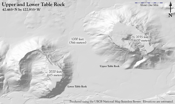
| Description | A terrain map of Upper and Lower Table Rock. (Description added by Little Mountain 5) |
| Date | |
| Source | Created by the author using Fireworks MX 2004, and information from the USGS National Map Seamless Server, which is in the public domain (authored by the USGS). Data available from U.S. Geological Survey, EROS Data Center, Sioux Falls, SD.[1] |
| Author | ZabMilenko |
Licensing
| I, the copyright holder of this work, release this work into the public domain. This applies worldwide. In some countries this may not be legally possible; if so: I grant anyone the right to use this work for any purpose, without any conditions, unless such conditions are required by law. |
Original upload log
The original description page was here. All following user names refer to en.wikipedia.
| Upload date | User | Bytes | Dimensions | Comment |
|---|---|---|---|---|
| 2009-05-06 11:01:54 | ZabMilenko | 210922 | 668×399 | I created this image myself using Fireworks MX 2004 and information from the USGS National Map Seamless Server. ~~~~ |
File history
Click on a date/time to view the file as it appeared at that time.
| Date/Time | Thumbnail | Dimensions | User | Comment | |
|---|---|---|---|---|---|
| current | 14:40, 8 October 2009 | | 668 × 399 (206 KB) | CommonsHelper2 Bot | {{BotMoveToCommons|en.wikipedia|year={{subst:CURRENTYEAR}}|month={{subst:CURRENTMONTHNAME}}|day={{subst:CURRENTDAY}}}} I created this image myself using Fireworks MX 2004 and information from the USGS National Map Seamless Server. [[:en:User:ZabMilenko| |
File usage
The following pages on the English Wikipedia use this file (pages on other projects are not listed):
- Upper and Lower Table Rock
- User:Finetooth/Honors
- User:Wadewitz/TrophyCase
- User talk:Auntieruth55/Archive 4
- User talk:Awickert/Archive 3
- User talk:Ceranthor/Archive 16
- User talk:Finetooth/Archive 8
- User talk:Fowler&fowler/Archive 13
- User talk:Ruhrfisch/Archive26
- User talk:Wadewitz/Archive 42
- Template:Infobox protected area/testcases
- Portal:Oregon/Selected article
- Portal:Oregon/Selected article/81
Global file usage
The following other wikis use this file:
- Usage on es.wikipedia.org
- Usage on fr.wikipedia.org