
File:Uerdinger und Karlsruher Linie.png

Size of this preview: 614 × 599 pixels. Other resolutions: 246 × 240 pixels | 492 × 480 pixels | 787 × 768 pixels | 1,158 × 1,130 pixels.
Original file (1,158 × 1,130 pixels, file size: 1.23 MB, MIME type: image/png)
| This is a file from the Wikimedia Commons. Information from its description page there is shown below. Commons is a freely licensed media file repository. You can help. |
Summary
| Description |
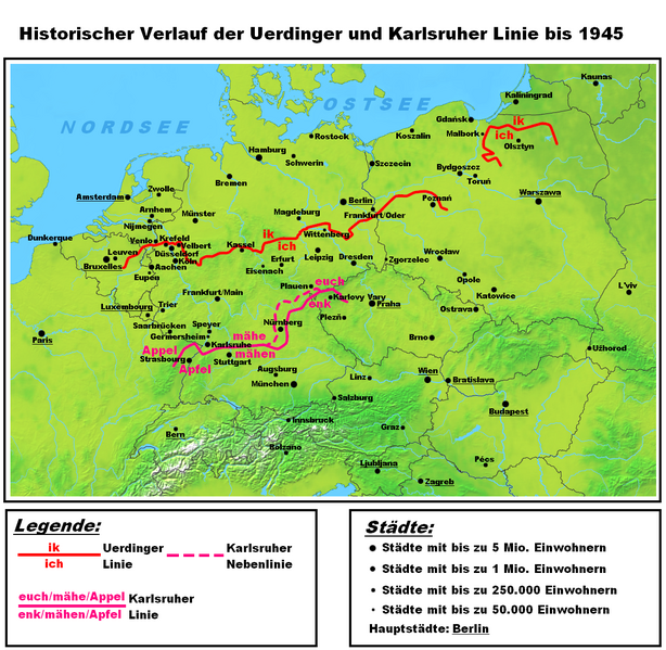
Deutsch: Darstellungskarte des historischen Verlaufes der Uerdinger und der Karlsruher Linie als alte Trenngrenze zwischen Nieder- und Mitteldeutsch. Die hochdeutschen Sprachinseln nördlich der Benrather Linie werden nicht dargestellt, da es sich hierbei nicht um das Ergebnis einer Lautverschiebung, sondern um spätere Siedlungsbewegungen von Süden nach Norden handelt. Es wurde auch bewusst auf die Darstellung jeglicher Sprachgrenzen verzichtet. |
| Date | |
| Source | Own work |
| Author | Hardcore-Mike |
Licensing
I, the copyright holder of this work, hereby publish it under the following license:
This file is licensed under the Creative Commons Attribution 3.0 Unported license.
- You are free:
- to share – to copy, distribute and transmit the work
- to remix – to adapt the work
- Under the following conditions:
- attribution – You must give appropriate credit, provide a link to the license, and indicate if changes were made. You may do so in any reasonable manner, but not in any way that suggests the licensor endorses you or your use.
File history
Click on a date/time to view the file as it appeared at that time.
| Date/Time | Thumbnail | Dimensions | User | Comment | |
|---|---|---|---|---|---|
| current | 00:44, 17 October 2010 | | 1,158 × 1,130 (1.23 MB) | MicBy67 | Kleinigkeiten |
| 17:55, 16 October 2010 |  | 1,158 × 1,130 (1.23 MB) | MicBy67 | Schreibfehler in der Legende berichtigt | |
| 17:37, 16 October 2010 |  | 1,158 × 1,130 (1.23 MB) | MicBy67 | Komplett überarbeitet. Andere Farben und Neben-Isoglosse der Karlsruher Linie eingezeichnet | |
| 01:02, 11 October 2010 |  | 1,122 × 752 (666 KB) | MicBy67 | Karte verkleinert, Isoglossen überarbeitet und fehlendes Teil der Karlsruher Linie in Tschechien beigefügt. | |
| 19:48, 6 October 2010 |  | 2,805 × 1,880 (3.71 MB) | MicBy67 | {{Information |Description={{de|1=Darstellungskarte des historischen Verlaufes der Uerdinger und der Karlsruher Linie als alte Trenngrenze zwischen Nieder- und Mitteldeutsch. Es wurde bewußt auf die Darstellung jeglicher Sprachgrenzen verzichtet.}} |Sour |
File usage
The following pages on the English Wikipedia use this file (pages on other projects are not listed):
Global file usage
The following other wikis use this file:
- Usage on als.wikipedia.org
- Usage on ca.wikipedia.org
- Usage on de.wikipedia.org
- Usage on es.wikipedia.org
- Usage on fr.wikipedia.org
- Usage on fy.wikipedia.org
- Usage on li.wikipedia.org
- Usage on nds.wikipedia.org
- Usage on nl.wikipedia.org
- Usage on ru.wikipedia.org
- Usage on uk.wikipedia.org
- Usage on vls.wikipedia.org
- Usage on zh.wikipedia.org