
File:US 131 and Stadium Drive Kalamazoo.jpg

Size of this preview: 800 × 549 pixels. Other resolutions: 320 × 219 pixels | 640 × 439 pixels | 1,024 × 702 pixels | 1,280 × 878 pixels | 2,560 × 1,756 pixels | 3,284 × 2,252 pixels.
Original file (3,284 × 2,252 pixels, file size: 2.33 MB, MIME type: image/jpeg)
| This is a file from the Wikimedia Commons. Information from its description page there is shown below. Commons is a freely licensed media file repository. You can help. |
Summary
| Description |
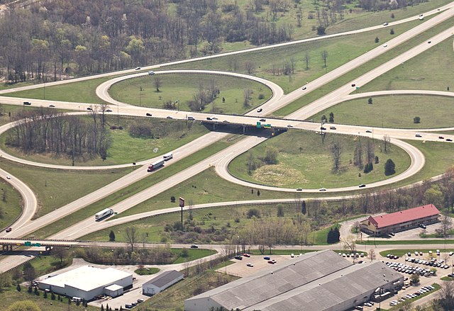
Another aerial shot from my lunch time in the air. I like the isometric view of the land you get when you're flying. I DON'T like the haze and other atmospheric effects. All the shots worth keeping needed a pretty heavy white balance and then a significant boost in contrast/blacks to cut through the drabness. Shooting in RAW only made the correction seem more necessary. For those of you who might actually know this intersection, we're looking south at the underpass of US 131 and at the overpass of Stadium drive. |
| Date | |
| Source |
They're After Me Lucky Highways!
|
| Author | Brian Wolfe from Kalamazoo, United States |
| Camera location | | View this and other nearby images on: OpenStreetMap |
|---|
| This is a retouched picture, which means that it has been digitally altered from its original version. Modifications: Cropped image. Modifications made by Imzadi1979.
|
Licensing
This file is licensed under the Creative Commons Attribution 2.0 Generic license.
- You are free:
- to share – to copy, distribute and transmit the work
- to remix – to adapt the work
- Under the following conditions:
- attribution – You must give appropriate credit, provide a link to the license, and indicate if changes were made. You may do so in any reasonable manner, but not in any way that suggests the licensor endorses you or your use.
| This image, originally posted to Flickr, was reviewed on January 28, 2011 by the administrator or reviewer File Upload Bot (Magnus Manske), who confirmed that it was available on Flickr under the stated license on that date. |
File history
Click on a date/time to view the file as it appeared at that time.
| Date/Time | Thumbnail | Dimensions | User | Comment | |
|---|---|---|---|---|---|
| current | 11:20, 28 January 2011 | | 3,284 × 2,252 (2.33 MB) | Imzadi1979 | Cropped image |
| 10:56, 28 January 2011 |  | 3,291 × 3,291 (4.76 MB) | File Upload Bot (Magnus Manske) | {{Information |Description=Another aerial shot from my lunch time in the air. I like the isometric view of the land you get when you're flying. I DON'T like the haze and other atmospheric effects. All the shots worth keeping needed a pretty heavy white b |
File usage
The following pages on the English Wikipedia use this file (pages on other projects are not listed):
Global file usage
The following other wikis use this file:
- Usage on de.wikipedia.org
- Usage on pl.wikipedia.org