
File:Training mast at H.M.S. Ganges - geograph.org.uk - 1247847.jpg
Size of this preview: 429 × 599 pixels. Other resolutions: 172 × 240 pixels | 458 × 640 pixels.
Original file (458 × 640 pixels, file size: 54 KB, MIME type: image/jpeg)
| This is a file from the Wikimedia Commons. Information from its description page there is shown below. Commons is a freely licensed media file repository. You can help. |
Summary
| Description |
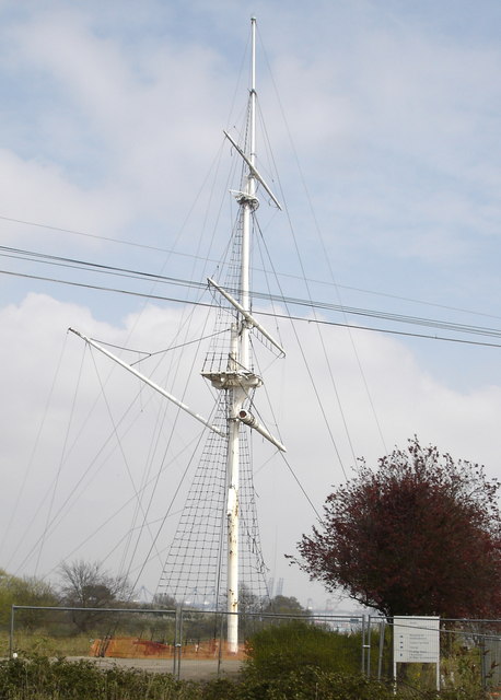
English: Training mast at H.M.S. Ganges H.M.S. Ganges was a training establishment for the Royal Navy. My dad was here as a 15-year old cadet in 1947, and he told me that on fine Sunday afternoons (their only free time) he and his friends would sit on the lowest yardarm on the mast to soak up the sun. Every cadet had to climb to the semi-circular platform just below the highest yardarm at least once during their training; the bravest (not my dad!) climbed to the very top of the mast and stood on the 12-inch diameter cap. |
| Date | |
| Source | From geograph.org.uk |
| Author | Oxymoron |
| Attribution (required by the license) | Oxymoron / Training mast at H.M.S. Ganges / |
| Camera location | | View this and other nearby images on: OpenStreetMap |
|---|
_heading:90.00&language=en)
| Object location | | View this and other nearby images on: OpenStreetMap |
|---|
_heading:90.00&language=en)
Licensing

|
This image was taken from the Geograph project collection. See this photograph's page on the Geograph website for the photographer's contact details. The copyright on this image is owned by Oxymoron and is licensed for reuse under the Creative Commons Attribution-ShareAlike 2.0 license.
|
This file is licensed under the Creative Commons Attribution-Share Alike 2.0 Generic license.
Attribution: Oxymoron
- You are free:
- to share – to copy, distribute and transmit the work
- to remix – to adapt the work
- Under the following conditions:
- attribution – You must give appropriate credit, provide a link to the license, and indicate if changes were made. You may do so in any reasonable manner, but not in any way that suggests the licensor endorses you or your use.
- share alike – If you remix, transform, or build upon the material, you must distribute your contributions under the same or compatible license as the original.
File history
Click on a date/time to view the file as it appeared at that time.
| Date/Time | Thumbnail | Dimensions | User | Comment | |
|---|---|---|---|---|---|
| current | 18:08, 26 February 2011 | | 458 × 640 (54 KB) | GeographBot | == {{int:filedesc}} == {{Information |description={{en|1=Training mast at H.M.S. Ganges H.M.S. Ganges was a training establishment for the Royal Navy. My dad was here as a 15-year old cadet in 1947, and he told me that on fine Sunday afternoons (their onl |
File usage
The following pages on the English Wikipedia use this file (pages on other projects are not listed):