
File:Toubou.png
No higher resolution available.
Toubou.png (640 × 578 pixels, file size: 778 KB, MIME type: image/png)
| This is a file from the Wikimedia Commons. Information from its description page there is shown below. Commons is a freely licensed media file repository. You can help. |
Summary
| Description |
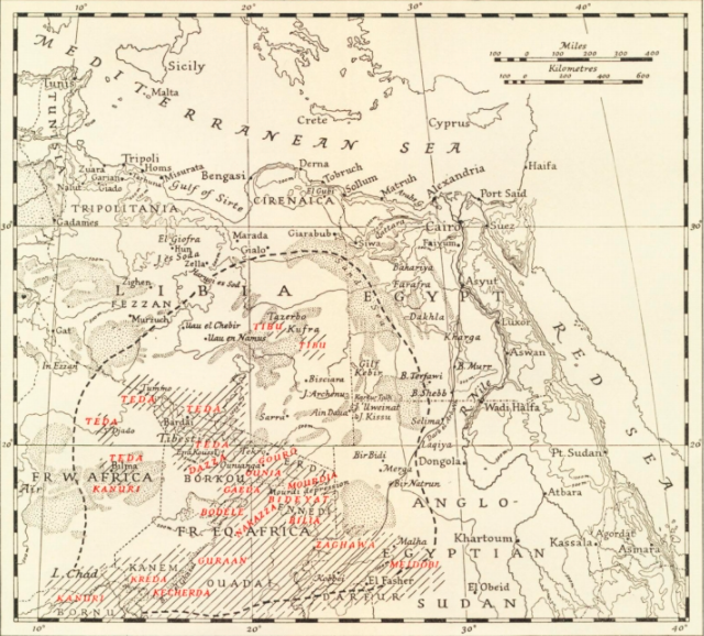
English: This map represents accurately the zone of influence of the Toubou tribe. A tribe in the Sahara that occupies 4 countries; Libya, Chad, Niger, and Sudan. |
| Date | between 1870s and 1940s |
| Source | https://www-jstor-org.myaccess.library.utoronto.ca/stable/1789494?seq=20#metadata_info_tab_contents |
| Author | Major R.F Peel |
Licensing
This file is licensed under the Creative Commons Attribution-Share Alike 4.0 International license.
- You are free:
- to share – to copy, distribute and transmit the work
- to remix – to adapt the work
- Under the following conditions:
- attribution – You must give appropriate credit, provide a link to the license, and indicate if changes were made. You may do so in any reasonable manner, but not in any way that suggests the licensor endorses you or your use.
- share alike – If you remix, transform, or build upon the material, you must distribute your contributions under the same or compatible license as the original.
File history
Click on a date/time to view the file as it appeared at that time.
| Date/Time | Thumbnail | Dimensions | User | Comment | |
|---|---|---|---|---|---|
| current | 21:38, 28 November 2021 | | 640 × 578 (778 KB) | SaharanOracle | Uploaded a work by Major R.F Peel from https://www-jstor-org.myaccess.library.utoronto.ca/stable/1789494?seq=20#metadata_info_tab_contents with UploadWizard |
File usage
The following pages on the English Wikipedia use this file (pages on other projects are not listed):