
File:Thorpeness Windmill - geograph.org.uk - 1588461.jpg
No higher resolution available.
Thorpeness_Windmill_-_geograph.org.uk_-_1588461.jpg (419 × 426 pixels, file size: 138 KB, MIME type: image/jpeg)
| This is a file from the Wikimedia Commons. Information from its description page there is shown below. Commons is a freely licensed media file repository. You can help. |
Summary
| Description |
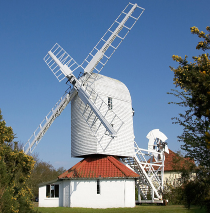
English: Thorpeness Windmill Built in 1803, Thorpeness Windmill was originally a corn mill at the nearby village of Aldringham. It was purchased and moved to its present site in 1923, where it was converted to pump water by sail power. Thirty years ago it was restored and purchased by Suffolk County Council, and today it is still a fully functioning windmill, housing displays on Thorpeness village and areas of outstanding beauty in Suffolk. For the more adventurous visitors, it is worth climbing the steep wooden steps to view the inner workings of the mill. |
| Date | |
| Source | From geograph.org.uk |
| Author | Cameraman |
| Attribution (required by the license) | Cameraman / Thorpeness Windmill / |
| Camera location | | View this and other nearby images on: OpenStreetMap |
|---|
_heading:112.00&language=en)
| Object location | | View this and other nearby images on: OpenStreetMap |
|---|
_heading:112.00&language=en)
Licensing

|
This image was taken from the Geograph project collection. See this photograph's page on the Geograph website for the photographer's contact details. The copyright on this image is owned by Cameraman and is licensed for reuse under the Creative Commons Attribution-ShareAlike 2.0 license.
|
This file is licensed under the Creative Commons Attribution-Share Alike 2.0 Generic license.
Attribution: Cameraman
- You are free:
- to share – to copy, distribute and transmit the work
- to remix – to adapt the work
- Under the following conditions:
- attribution – You must give appropriate credit, provide a link to the license, and indicate if changes were made. You may do so in any reasonable manner, but not in any way that suggests the licensor endorses you or your use.
- share alike – If you remix, transform, or build upon the material, you must distribute your contributions under the same or compatible license as the original.
File history
Click on a date/time to view the file as it appeared at that time.
| Date/Time | Thumbnail | Dimensions | User | Comment | |
|---|---|---|---|---|---|
| current | 14:26, 13 December 2011 | | 419 × 426 (138 KB) | Cropbot | upload cropped version, operated by User:jay8g. Summary: cropped |
| 01:14, 4 March 2011 |  | 640 × 449 (197 KB) | GeographBot | == {{int:filedesc}} == {{Information |description={{en|1=Thorpeness Windmill Built in 1803, Thorpeness Windmill was originally a corn mill at the nearby village of Aldringham. It was purchased and moved to its present site in 1923, where it was converted |
File usage
The following pages on the English Wikipedia use this file (pages on other projects are not listed):
Global file usage
The following other wikis use this file:
- Usage on uk.wikipedia.org