
File:Tafarn y bwlch on the edge of the moorland - geograph.org.uk - 302952.jpg
No higher resolution available.
Tafarn_y_bwlch_on_the_edge_of_the_moorland_-_geograph.org.uk_-_302952.jpg (640 × 480 pixels, file size: 59 KB, MIME type: image/jpeg)
| This is a file from the Wikimedia Commons. Information from its description page there is shown below. Commons is a freely licensed media file repository. You can help. |
Summary
| Description |
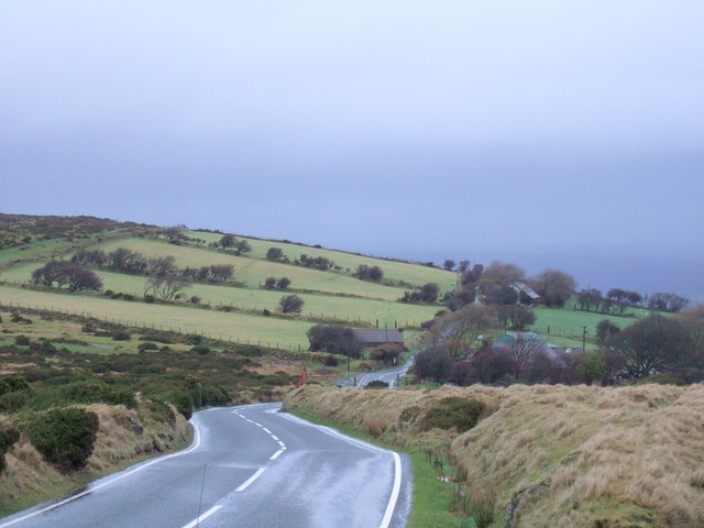
English: Tafarn y bwlch on the edge of the moorland The name of this cluster of houses means Tavern [at] the pass. The hostelry no longer exists but was once a crucial stop on this long, bleak upland route between Cardigan and Haverfordwest. The road, now the B4329, was used in mediaeval times and subsequently turnpiked. This point still marks the boundary between fields and unenclosed moorland, an area where travellers would have been exposed to wild weather and wilder brigands before the invention of cars. |
| Date | |
| Source | From geograph.org.uk |
| Author | ceridwen |
| Attribution (required by the license) | ceridwen / Tafarn y bwlch on the edge of the moorland / |
| Camera location | | View this and other nearby images on: OpenStreetMap |
|---|
_heading:22.00&language=en)
| Object location | | View this and other nearby images on: OpenStreetMap |
|---|
_heading:22.00&language=en)
Licensing

|
This image was taken from the Geograph project collection. See this photograph's page on the Geograph website for the photographer's contact details. The copyright on this image is owned by ceridwen and is licensed for reuse under the Creative Commons Attribution-ShareAlike 2.0 license.
|
This file is licensed under the Creative Commons Attribution-Share Alike 2.0 Generic license.
Attribution: ceridwen
- You are free:
- to share – to copy, distribute and transmit the work
- to remix – to adapt the work
- Under the following conditions:
- attribution – You must give appropriate credit, provide a link to the license, and indicate if changes were made. You may do so in any reasonable manner, but not in any way that suggests the licensor endorses you or your use.
- share alike – If you remix, transform, or build upon the material, you must distribute your contributions under the same or compatible license as the original.
File history
Click on a date/time to view the file as it appeared at that time.
| Date/Time | Thumbnail | Dimensions | User | Comment | |
|---|---|---|---|---|---|
| current | 22:39, 22 December 2010 | | 640 × 480 (59 KB) | GeographBot | == {{int:filedesc}} == {{Information |description={{en|1=Tafarn y bwlch on the edge of the moorland The name of this cluster of houses means Tavern [at] the pass. The hostelry no longer exists but was once a crucial stop on this long, bleak upland route b |
File usage
The following pages on the English Wikipedia use this file (pages on other projects are not listed):