
File:Stobhall Castle and chapel - geograph.org.uk - 82721.jpg
No higher resolution available.
Stobhall_Castle_and_chapel_-_geograph.org.uk_-_82721.jpg (309 × 205 pixels, file size: 74 KB, MIME type: image/jpeg)
| This is a file from the Wikimedia Commons. Information from its description page there is shown below. Commons is a freely licensed media file repository. You can help. |
Summary
| Description |
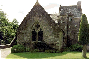
English: Stobhall Castle and chapel. In the middle of the 14th century Sir John Drummond married the last of the Montfichets who owned the lands of Cargill and Stobhall. They moved from about three miles away to Stobhall where the Chapel may already have been standing. Recently the plain plaster ceiling of the passage was taken down and underneath were found the painted beams c. 1578. See http://www.stobhall.com/pages/history.html . |
| Date | |
| Source | From geograph.org.uk |
| Author | Andrew Mitchell |
| Attribution (required by the license) | Andrew Mitchell / Stobhall Castle and chapel / |
| Camera location | | View this and other nearby images on: OpenStreetMap |
|---|
_heading:22.00&language=en)
| Object location | | View this and other nearby images on: OpenStreetMap |
|---|
_heading:22.00&language=en)
Licensing

|
This image was taken from the Geograph project collection. See this photograph's page on the Geograph website for the photographer's contact details. The copyright on this image is owned by Andrew Mitchell and is licensed for reuse under the Creative Commons Attribution-ShareAlike 2.0 license.
|
This file is licensed under the Creative Commons Attribution-Share Alike 2.0 Generic license.
Attribution: Andrew Mitchell
- You are free:
- to share – to copy, distribute and transmit the work
- to remix – to adapt the work
- Under the following conditions:
- attribution – You must give appropriate credit, provide a link to the license, and indicate if changes were made. You may do so in any reasonable manner, but not in any way that suggests the licensor endorses you or your use.
- share alike – If you remix, transform, or build upon the material, you must distribute your contributions under the same or compatible license as the original.
File history
Click on a date/time to view the file as it appeared at that time.
| Date/Time | Thumbnail | Dimensions | User | Comment | |
|---|---|---|---|---|---|
| current | 23:58, 30 January 2010 | | 309 × 205 (74 KB) | GeographBot | == {{int:filedesc}} == {{Information |description={{en|1=Stobhall Castle and chapel. In the middle of the 14th century Sir John Drummond married the last of the Montfichets who owned the lands of Cargill and Stobhall. They moved from about three miles awa |
File usage
The following pages on the English Wikipedia use this file (pages on other projects are not listed):
Global file usage
The following other wikis use this file:
- Usage on de.wikipedia.org
- Usage on www.wikidata.org