
File:Souk-ahras barage.jpg

Size of this preview: 800 × 574 pixels. Other resolutions: 320 × 230 pixels | 640 × 459 pixels | 1,024 × 734 pixels | 1,280 × 918 pixels | 1,574 × 1,129 pixels.
Original file (1,574 × 1,129 pixels, file size: 249 KB, MIME type: image/jpeg)
| This is a file from the Wikimedia Commons. Information from its description page there is shown below. Commons is a freely licensed media file repository. You can help. |
Summary
| Description |
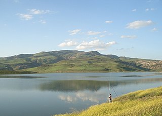
العربية: صورة لبحيرة .مجمع مائي. سد عين الدالية في منطقة سوق أهراس في الشمال الشرقي للجزائر
English: the Ain-dalia dam, Souk Ahras, Algeria |
| Date | |
| Source | Own work |
| Author | Abdallahdjabi |
| Camera location | | View this and other nearby images on: OpenStreetMap |
|---|
|
Licensing
I, the copyright holder of this work, hereby publish it under the following licenses:
This file is licensed under the Creative Commons Attribution-Share Alike 3.0 Unported license.
- You are free:
- to share – to copy, distribute and transmit the work
- to remix – to adapt the work
- Under the following conditions:
- attribution – You must give appropriate credit, provide a link to the license, and indicate if changes were made. You may do so in any reasonable manner, but not in any way that suggests the licensor endorses you or your use.
- share alike – If you remix, transform, or build upon the material, you must distribute your contributions under the same or compatible license as the original.

|
Permission is granted to copy, distribute and/or modify this document under the terms of the GNU Free Documentation License, Version 1.2 or any later version published by the Free Software Foundation; with no Invariant Sections, no Front-Cover Texts, and no Back-Cover Texts. A copy of the license is included in the section entitled GNU Free Documentation License. |
You may select the license of your choice.
File history
Click on a date/time to view the file as it appeared at that time.
| Date/Time | Thumbnail | Dimensions | User | Comment | |
|---|---|---|---|---|---|
| current | 21:07, 24 May 2009 | | 1,574 × 1,129 (249 KB) | Mo7amedsalim | horizing |
| 21:02, 24 May 2009 |  | 1,574 × 1,129 (249 KB) | Mo7amedsalim | horizing | |
| 22:45, 19 May 2009 |  | 1,632 × 1,224 (854 KB) | Abdallahdjabi | {{Information |Description=Category:Arab Countries Pictures |Source=Own work |Author=Abdallahdjabi |Date=19/05/2009 |Permission= |other_versions= }} <!--{{ImageUpload|full}}--> |
File usage
The following pages on the English Wikipedia use this file (pages on other projects are not listed):
Global file usage
The following other wikis use this file:
- Usage on ar.wikipedia.org
- ولاية سوق أهراس
- ويكيبيديا:ترشيحات الصور المختارة/ملف:Souk-ahras barage.jpg
- ويكيبيديا:صور مختارة/أماكن/مناظر طبيعية
- الحنانشة
- بوابة:الوطن العربي/صورة مختارة/أرشيف
- ويكيبيديا:صورة اليوم المختارة/يونيو 2015
- قالب:صورة اليوم المختارة/2015-06-17
- بوابة:الوطن العربي/صورة مختارة/47
- ويكيبيديا:صورة اليوم المختارة/أغسطس 2016
- قالب:صورة اليوم المختارة/2016-08-22
- سد عين الدالية
- نقاش المستخدم:Abdallahdjabi/أرشيف 1
- ويكيبيديا:صورة اليوم المختارة/يونيو 2018
- قالب:صورة اليوم المختارة/2018-06-11
- ويكيبيديا:صورة اليوم المختارة/نوفمبر 2019
- قالب:صورة اليوم المختارة/2019-11-24
- بوابة:بحيرات/صورة مختارة
- ويكيبيديا:صورة اليوم المختارة/مايو 2022
- قالب:صورة اليوم المختارة/2022-05-10
- بوابة:بحيرات/صورة مختارة/3
- Usage on arz.wikipedia.org
- Usage on el.wikipedia.org
- Usage on es.wikipedia.org
- Usage on fa.wikipedia.org
- Usage on fr.wikipedia.org
- Usage on it.wikipedia.org
- Usage on ja.wikipedia.org
- Usage on pt.wikipedia.org
- Usage on ro.wikipedia.org
- Usage on tum.wikipedia.org
- Usage on www.wikidata.org
- Usage on yo.wikipedia.org
- Usage on zu.wikipedia.org