
File:Sluggan Bridge 2009 - geograph.org.uk - 1593484.jpg
No higher resolution available.
Sluggan_Bridge_2009_-_geograph.org.uk_-_1593484.jpg (640 × 480 pixels, file size: 100 KB, MIME type: image/jpeg)
| This is a file from the Wikimedia Commons. Information from its description page there is shown below. Commons is a freely licensed media file repository. You can help. |
Summary
| Description |
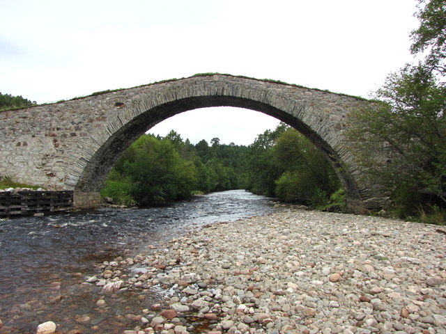
English: Sluggan Bridge crosses the Dulnain River on the old General Wade Military road (originally constructed c1729). The original two arched bridge was washed away during the great flood of the 3rd of August 1829. This large single span bridge, built in the 1830s has undergone a major repair in 2001 - 2002, by Sustrans as part of the National Cycle Network. |
||
| Date | |||
| Source | From geograph.org.uk | ||
| Author | John Tustin | ||
| Permission (Reusing this file) |
This file is licensed under the Creative Commons Attribution-Share Alike 2.0 Generic license. Attribution: John Tustin
|
||
| Attribution (required by the license) | John Tustin / Sluggan Bridge 2009 / | ||

| Camera location | | View this and other nearby images on: OpenStreetMap |
|---|
_heading:22.00&language=en)
| Object location | | View this and other nearby images on: OpenStreetMap |
|---|
_heading:22.00&language=en)
File history
Click on a date/time to view the file as it appeared at that time.
| Date/Time | Thumbnail | Dimensions | User | Comment | |
|---|---|---|---|---|---|
| current | 04:07, 4 March 2011 | | 640 × 480 (100 KB) | GeographBot | == {{int:filedesc}} == {{Information |description={{en|1=Sluggan Bridge 2009 Sluggan Bridge crosses the Dulnain River on the old General Wade Military road (originally constructed c1729). The original two arched bridge was washed away during the great fl |
File usage
The following pages on the English Wikipedia use this file (pages on other projects are not listed):