
File:Sessay station site geograph-3996179-by-Ben-Brooksbank.jpg
Size of this preview: 800 × 453 pixels. Other resolutions: 320 × 181 pixels | 640 × 363 pixels | 1,024 × 580 pixels | 1,280 × 725 pixels | 2,396 × 1,358 pixels.
Original file (2,396 × 1,358 pixels, file size: 3.22 MB, MIME type: image/jpeg)
| This is a file from the Wikimedia Commons. Information from its description page there is shown below. Commons is a freely licensed media file repository. You can help. |
Summary
| Description |
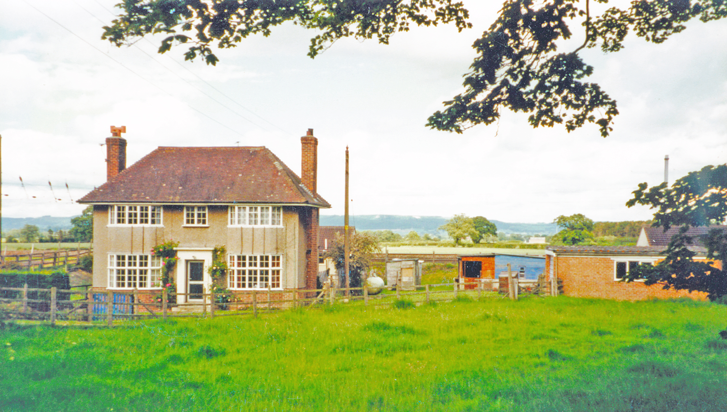
English: Site of former Sessay station, ECML 2002. View eastward from the Dalton - Sessay road. Sessay station was on the ex-NER York (to right) - Northallerton (to left) section of the East Coast Main Line and was completely rebuilt during the widening works here in World War Two, completed 5/43. The station was closed to passengers from 15/9/58, to goods from 10/8/64, but it is possible that this house - although rather grand, had been the station house, because the architecture is very similar to that of other stations rebuilt during the earlier widenings along this stretch carried out in the 1930s |
| Date | |
| Source | From geograph.org.uk |
| Author | Ben Brooksbank |
| Permission (Reusing this file) |
Creative Commons Attribution Share-alike license 2.0 |
| Attribution (required by the license) | Ben Brooksbank / Site of former Sessay station, ECML 2002 / |
| Camera location | | View this and other nearby images on: OpenStreetMap |
|---|
Licensing

|
This image was taken from the Geograph project collection. See this photograph's page on the Geograph website for the photographer's contact details. The copyright on this image is owned by Ben Brooksbank and is licensed for reuse under the Creative Commons Attribution-ShareAlike 2.0 license.
|
This file is licensed under the Creative Commons Attribution-Share Alike 2.0 Generic license.
Attribution: Ben Brooksbank
- You are free:
- to share – to copy, distribute and transmit the work
- to remix – to adapt the work
- Under the following conditions:
- attribution – You must give appropriate credit, provide a link to the license, and indicate if changes were made. You may do so in any reasonable manner, but not in any way that suggests the licensor endorses you or your use.
- share alike – If you remix, transform, or build upon the material, you must distribute your contributions under the same or compatible license as the original.
File history
Click on a date/time to view the file as it appeared at that time.
| Date/Time | Thumbnail | Dimensions | User | Comment | |
|---|---|---|---|---|---|
| current | 14:42, 14 June 2014 | | 2,396 × 1,358 (3.22 MB) | Chevin | == {{int:filedesc}} == {{Information |Description={{en|1='''Site of former Sessay station, ECML 2002.'''<br /> View eastward from the Dalton - Sessay road. Sessay station was on the ex-NER York (to right) - Northallerton (to left) section of the East C... |
File usage
The following pages on the English Wikipedia use this file (pages on other projects are not listed):
Global file usage
The following other wikis use this file:
- Usage on www.wikidata.org