
File:Roman harbors and fleets Augustus-Severus.png

Size of this preview: 800 × 551 pixels. Other resolutions: 320 × 221 pixels | 640 × 441 pixels | 1,024 × 706 pixels | 1,280 × 882 pixels | 2,052 × 1,414 pixels.
Original file (2,052 × 1,414 pixels, file size: 256 KB, MIME type: image/png)
| This is a file from the Wikimedia Commons. Information from its description page there is shown below. Commons is a freely licensed media file repository. You can help. |
Summary
| Description |
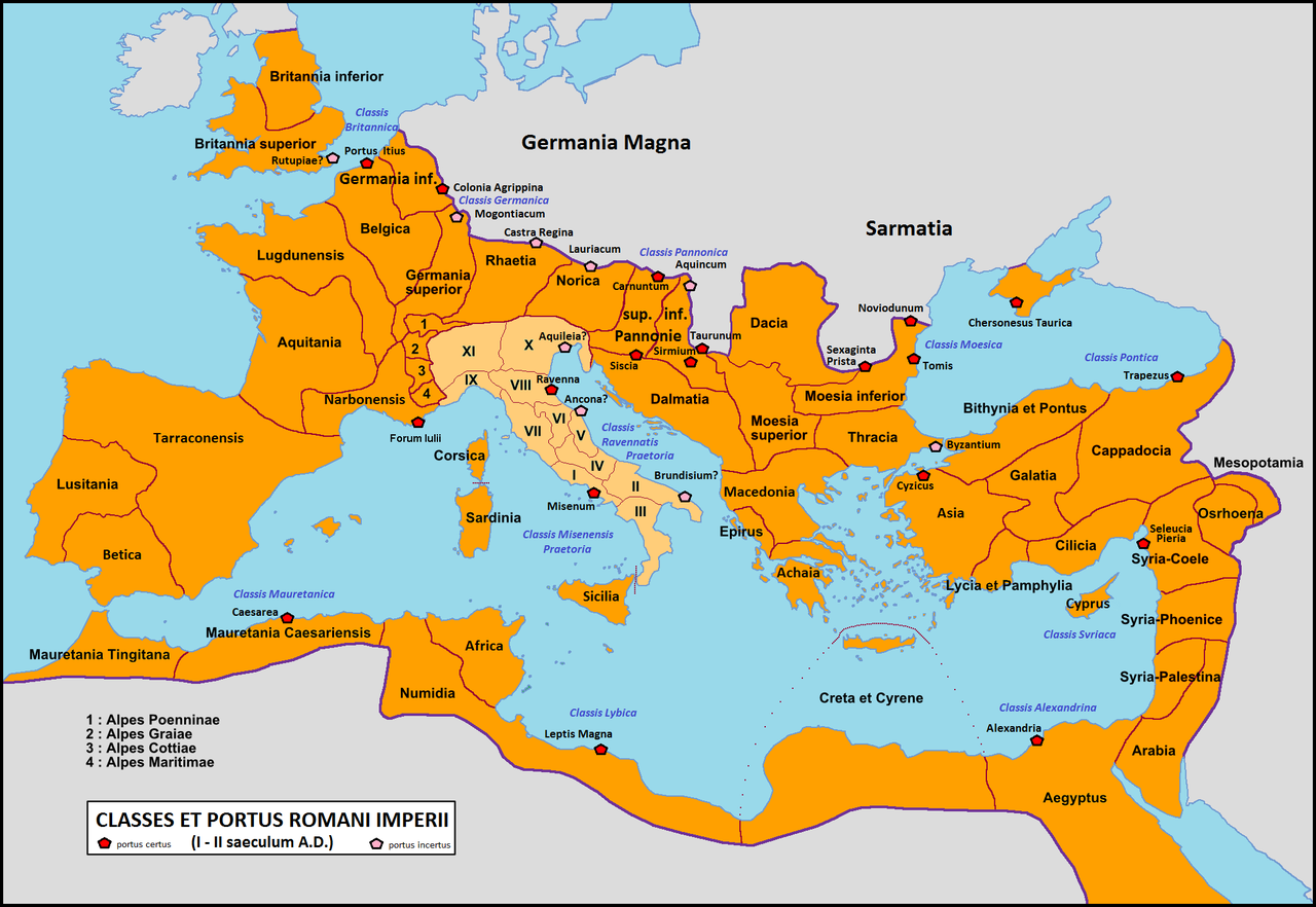
English: Map of the Roman Empire with main harbors and fleets from Augustus to Septimius Severus Italiano: Mappa dell'Impero romano con i principali porti e flotte, da Augusto a Settimio Severo. |
| Date | (UTC) |
| Source |
This file was derived from: Roman Empire with provinces in 210 AD.png: |
| Author |
|
| This is a retouched picture, which means that it has been digitally altered from its original version. Modifications: Colours. Add harbours and fleets.. The original can be viewed here: Roman Empire with provinces in 210 AD.png:
|
Licensing
I, the copyright holder of this work, hereby publish it under the following license:
| I, the copyright holder of this work, release this work into the public domain. This applies worldwide. In some countries this may not be legally possible; if so: I grant anyone the right to use this work for any purpose, without any conditions, unless such conditions are required by law. |
Original upload log
This image is a derivative work of the following images:
- File:Roman_Empire_with_provinces_in_210_AD.png licensed with PD-self
- 2009-03-10T12:49:45Z Mandrak 2052x1414 (266689 Bytes) {{Information |Description={{en|1=Map of the Roman Empire with the provinces of 210 AD.}} {{fr|1=Carte de l'Empire romain avec ses provinces en 210 ap. J.-C.}} |Source=travail personnel (own work) |Author=[[User:Mandrak|Mandr
Uploaded with derivativeFX
File history
Click on a date/time to view the file as it appeared at that time.
| Date/Time | Thumbnail | Dimensions | User | Comment | |
|---|---|---|---|---|---|
| current | 16:55, 3 February 2012 | | 2,052 × 1,414 (256 KB) | Cristiano64 | add Forum Iulii in Gallia Narbonensis |
| 16:39, 3 February 2012 |  | 2,052 × 1,414 (343 KB) | Cristiano64 | == {{int:filedesc}} == {{Information |Description={{en|1=Map of the Roman Empire with main harbors and fleets from Augustus to Septimius Severus}} {{it|1=Mappa dell'Impero romano con i principali porti e flotte, da Augusto a Settimio Severo.}} |Source={{D |
File usage
The following pages on the English Wikipedia use this file (pages on other projects are not listed):
Global file usage
The following other wikis use this file:
- Usage on de.wikipedia.org
- Usage on eo.wikipedia.org
- Usage on es.wikipedia.org
- Usage on et.wikipedia.org
- Usage on it.wikipedia.org
- Usage on ru.wikipedia.org