
File:Relief Map of Kazakhstan.png

Size of this preview: 800 × 457 pixels. Other resolutions: 320 × 183 pixels | 640 × 366 pixels | 1,200 × 686 pixels.
Original file (1,200 × 686 pixels, file size: 1.24 MB, MIME type: image/png)
| This is a file from the Wikimedia Commons. Information from its description page there is shown below. Commons is a freely licensed media file repository. You can help. |
Summary
| Description |
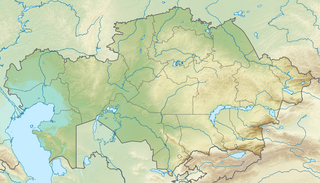
English: Location map of Kazakhstan
Equirectangular projection, N/S stretching 150 %. Geographic limits of the map:
|
| Date | |
| Source |
|
| Author |
|
| Permission (Reusing this file) |
This file is licensed under the Creative Commons Attribution-Share Alike 3.0 Unported license.
|
File history
Click on a date/time to view the file as it appeared at that time.
| Date/Time | Thumbnail | Dimensions | User | Comment | |
|---|---|---|---|---|---|
| current | 17:10, 9 October 2022 | | 1,200 × 686 (1.24 MB) | NordNordWest | upd 2022 |
| 19:41, 26 August 2010 |  | 1,200 × 686 (1.39 MB) | Виктор В | =={{int:filedesc}}== {{Information |Description={{en|Location map of Kazakhstan}} Equirectangular projection, N/S stretching 150 %. Geographic limits of the map: * N: 56° N * S: 40° N * W: 46° E * E: 88° E |Source=*[[:File:Kazakhsta |
File usage
More than 100 pages use this file. The following list shows the first 100 pages that use this file only. A full list is available.
- 2003 Zhaosu earthquake
- 28 Panfilov Guardsmen Park
- Alakol Biosphere Reserve
- Almaty
- Altyn-Emel National Park
- Aqqanburlyq
- Auliye
- Ayagoz
- Ayke
- Ayr Mountains
- Barak Kol (lake)
- Barsa-Kelmes Nature Reserve
- Bartogay Lake
- Battle of Alexandrovsky Fort
- Bayanaul National Park
- Belukha Mountain
- Betpak-Dala
- Big Almaty Lake
- Bogen (river)
- Bolshoy Uzen
- Boralday (river)
- Bostobe Formation
- Burabay National Park
- Caspian Depression
- Central Asia
- Charyn
- Chu (river)
- Dabrazhin Formation
- Dzungarian Gate
- Ebita
- Eginsai Formation
- Emba (river)
- Gora Alagordy
- Ile-Alatau National Park
- Ilek (river)
- Irgiz (Turgay)
- Issyk kurgan
- Jankent
- Kalkutan
- Kamyslybas
- Kapchagay Reservoir
- Karachaganak Field
- Karatau Mountains
- Karatau Nature Reserve
- Kargaly (river)
- Karkaraly National Park
- Kazakh Uplands
- Kazakhstan Open
- Khan Tengri
- Kokshetau
- Kyzylarai
- Kyzylkum Desert
- Kürshim
- Lake Alakol
- Lake Balkhash
- Lake Burabay
- Lake Issyk
- Lake Jasybay
- Lake Kaindy
- Lake Kopa
- Lake Markakol
- Lake Sasykkol
- Lake Tengiz
- Lake Zaysan
- Lake Zerendi
- Lake Zhalanashkol
- List of national parks of Kazakhstan
- Maly Uzen
- Manrak Formation
- Moiynkum Desert
- Mugalzhar
- National Museum of the Republic of Kazakhstan
- Neocomian Sands (Kazakhstan)
- North Aral Sea
- Nura (river)
- Otrar
- Pik Talgar
- Rudnichnoye
- Ryn Desert
- Saryarka – Steppe and Lakes of Northern Kazakhstan
- Saur Mountains
- Sauyr Zhotasy
- Sawran (Kazakhstan)
- Sayramsu
- Shagan (Irtysh)
- Shagan (Ural)
- Shagan (lake)
- Shardara Dam
- Sherkala
- Shiderti
- Shyngyrlau (river)
- South Aral Sea
- Stanovoye
- Tanbaly
- Tarbagatai Mountains
- Terekty River
- Terisaqqan
- Uil
- Unionopterus
- Zhirkindek Formation
View more links to this file.
Global file usage
The following other wikis use this file:
- Usage on ar.wikipedia.org
- Usage on ast.wikipedia.org
- Usage on av.wikipedia.org
- Usage on azb.wikipedia.org
- Usage on az.wikipedia.org
- Balxaş
- Şablon:Yer xəritəsi Qazaxıstan
- Alagöl (Qazaxıstan)
- Mangistau yarımadası
- Aral gölü
- Vernı zəlzələsi (1887)
- Bozaşı yarımadası
- Spirkin Oseredok
- Janbay
- Durnev
- Tülen adaları
- Kulalı
- Manqışlaq körfəzi
- Böyük Peşnıye adaları
- Qazax körfəzi
- Kaydak körfəzi
- Myortvıy Kultuk körfəzi
- Qızılqum
- Üstyurd
- Mirzəçöl
- Aral Qaraqumu
- Çaqan gölü
- Bayanaul Milli Parkı
- İle-Alatau Milli Parkı
- Altın-Emel Milli Parkı
- Betpak-Dala
- Narın qumlar (səhra)
- Tauqum
- Jalqum
- Lyuqqum
- Barbıqum
- Böyük və Kiçik Porsuq
- Ayğırqum
- Sarıesik-Atırau
- Bestasqum
- Uzun-Aral
- Muyunqum
- Jamanqum
- Aralqum
- Barmaqqum
- Batpaysaqır
- Qaraqum (Almatı dairəsinin şimalında səhra)
- Qaraqum (Almatı dairəsinin cənubunda səhra)
- Muyunqum (Alma-ata dairsində səhra)
View more global usage of this file.