
File:Reconstruction of Hadrian's wall - geograph.org.uk - 407926.jpg
No higher resolution available.
Reconstruction_of_Hadrian's_wall_-_geograph.org.uk_-_407926.jpg (640 × 426 pixels, file size: 107 KB, MIME type: image/jpeg)
| This is a file from the Wikimedia Commons. Information from its description page there is shown below. Commons is a freely licensed media file repository. You can help. |
Summary
| Description |
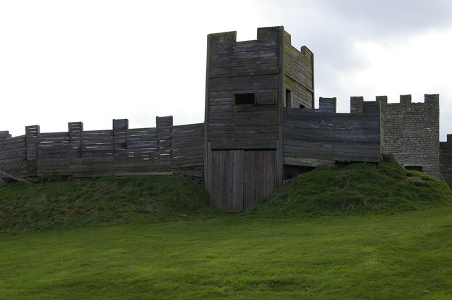
English: Reconstruction of Hadrian's wall The south west of the stone fort a Vindolanda are replicas of sections of Hadrian's wall. This is a reconstruction of the turf wall with a timber milecastle and gateway. Constructed in the 1970s, it has suffered from subsidence and undermining by rabbits. Part of a reconstruction of the stone wall can be seen on the right. |
| Date | |
| Source | From geograph.org.uk |
| Author | Phil Champion |
| Attribution (required by the license) | Phil Champion / Reconstruction of Hadrian's wall / |
| Camera location | | View this and other nearby images on: OpenStreetMap |
|---|
_heading:247.00&language=en)
| Object location | | View this and other nearby images on: OpenStreetMap |
|---|
_heading:247.00&language=en)
Licensing

|
This image was taken from the Geograph project collection. See this photograph's page on the Geograph website for the photographer's contact details. The copyright on this image is owned by Phil Champion and is licensed for reuse under the Creative Commons Attribution-ShareAlike 2.0 license.
|
This file is licensed under the Creative Commons Attribution-Share Alike 2.0 Generic license.
Attribution: Phil Champion
- You are free:
- to share – to copy, distribute and transmit the work
- to remix – to adapt the work
- Under the following conditions:
- attribution – You must give appropriate credit, provide a link to the license, and indicate if changes were made. You may do so in any reasonable manner, but not in any way that suggests the licensor endorses you or your use.
- share alike – If you remix, transform, or build upon the material, you must distribute your contributions under the same or compatible license as the original.
File history
Click on a date/time to view the file as it appeared at that time.
| Date/Time | Thumbnail | Dimensions | User | Comment | |
|---|---|---|---|---|---|
| current | 22:32, 3 February 2011 | | 640 × 426 (107 KB) | GeographBot | == {{int:filedesc}} == {{Information |description={{en|1=Reconstruction of Hadrian's wall The south west of the stone fort a Vindolanda are replicas of sections of Hadrian's wall. This is a reconstruction of the turf wall with a timber milecastle and gate |
File usage
The following pages on the English Wikipedia use this file (pages on other projects are not listed):
Global file usage
The following other wikis use this file:
- Usage on de.wikipedia.org
- Usage on fa.wikipedia.org