
File:Piton Fournaise eruptions animated-fr.gif

Size of this preview: 514 × 600 pixels. Other resolutions: 206 × 240 pixels | 411 × 480 pixels | 720 × 840 pixels.
Original file (720 × 840 pixels, file size: 678 KB, MIME type: image/gif, looped, 19 frames, 30 s)
| This is a file from the Wikimedia Commons. Information from its description page there is shown below. Commons is a freely licensed media file repository. You can help. |
Summary
| Description |
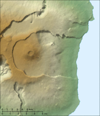
English: Animated map of the recent eruptions (1972 to 2000) of the Piton de la Fournaise shield volcano on the Réunion island.
Français : Carte animée des éruptions récentes (1972 à 2000) du volcan du Piton de la Fournaise sur l'île de la Réunion. |
||
| Date | |||
| Source |
Own work ; Topographic map : NASA Shuttle Radar Topography Mission (SRTM3 v.2) (public domain) edited with 3DEM from Visualization Software LLC ; Animation created with The GIMP ; References used : Maps from the Institut de Physique du Globe de Paris. |
||
| Author | Eric Gaba (Sting - fr:Sting) | ||
| Permission (Reusing this file) |
|
||
| Other versions |
|


Licensing
I, the copyright holder of this work, hereby publish it under the following licenses:

|
Permission is granted to copy, distribute and/or modify this document under the terms of the GNU Free Documentation License, Version 1.2 or any later version published by the Free Software Foundation; with no Invariant Sections, no Front-Cover Texts, and no Back-Cover Texts. A copy of the license is included in the section entitled GNU Free Documentation License. |
| This file is licensed under the Creative Commons Attribution-Share Alike 3.0 Unported license. | ||
| ||
| This licensing tag was added to this file as part of the GFDL licensing update. |
This file is licensed under the Creative Commons Attribution-Share Alike 2.5 Generic, 2.0 Generic and 1.0 Generic license.
- You are free:
- to share – to copy, distribute and transmit the work
- to remix – to adapt the work
- Under the following conditions:
- attribution – You must give appropriate credit, provide a link to the license, and indicate if changes were made. You may do so in any reasonable manner, but not in any way that suggests the licensor endorses you or your use.
- share alike – If you remix, transform, or build upon the material, you must distribute your contributions under the same or compatible license as the original.
You may select the license of your choice.
File history
Click on a date/time to view the file as it appeared at that time.
| Date/Time | Thumbnail | Dimensions | User | Comment | |
|---|---|---|---|---|---|
| current | 19:10, 13 June 2007 | | 720 × 840 (678 KB) | Sting | Forgotten scale |
| 13:56, 13 June 2007 |  | 720 × 840 (676 KB) | Sting | Lighter visual version (less crater names) | |
| 21:03, 12 June 2007 |  | 720 × 840 (687 KB) | Sting | {{Information |Description=Animated map of the recent eruptions (1972 to 2000) of the ''Piton de la Fournaise'' shield volcano on the Réunion island. |Source=Own work ;<br/>Topographic map : [http://www2.jpl |
File usage
The following pages on the English Wikipedia use this file (pages on other projects are not listed):
Global file usage
The following other wikis use this file:
- Usage on ar.wikipedia.org
- Usage on de.wikivoyage.org
- Usage on fr.wikipedia.org
- Usage on he.wikipedia.org
- Usage on pl.wikipedia.org
- Usage on sv.wikipedia.org
- Usage on zh.wikipedia.org