
File:PianotondoAndTraviSpiralTunnelsOnSouthernRampOfGotthardbahn.jpg

Original file (2,306 × 716 pixels, file size: 166 KB, MIME type: image/jpeg)
| This is a file from the Wikimedia Commons. Information from its description page there is shown below. Commons is a freely licensed media file repository. You can help. |
Summary
| Description |
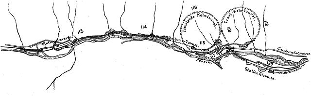
English: Outline of the Pianotondo and Travi spiral tunnels between Lavorgo station and former Giornico station (Giornico vecchio) on the southern ramp to the Gotthard tunnel from km 112 to 120.5. |
||||
| Date | 1914, book (or prior source predating the publication of volume 5 of Röll's encyclopedia in 1914) | ||||
| Source | Gotthardbahn in: Röll, V. Freiherr von: Enzyklopädie des Eisenbahnwesens, Band 5. Berlin, Wien 1914, S. 354-361. digitized version on www.zeno.org/Roell-1912 | ||||
| Author | Dietler, Hermann (1839-10-01 - 1924-01-24); Röll, Victor Freiherr von (1852-05-22 - 1922-10-12) | ||||
| Permission (Reusing this file) |
|
||||
The original German caption of the graph in the cited publication reads "Abb. 291. Linienentwicklung bei Giornico (Pianotondo- und Travi-Kehrtunnel)."
No scale, legend or indicator for the north south direction was provided with the map.
The travel distance along the Gotthard line from Immensee is indicated for each full kilometer by a small circular mark and the specified distance in km. The section shows the route from about km 112 to 120.5.
The graph shows the Ticino river flowing down the valley from left to right or approximately from NNW to SSE with the Lavorgo station at km 112.6 and the original Giornico station (Giornico vecchio) at ca. km 119.8. Later the Giornico station was moved about 2km further down the line to the still existing but also no longer operating Giornico station at km 121.7. The original station was build far outside the village to maintain approximatly equal distances between stations and was removed later.
Going south on the Gotthardbahn having passed Lavorgo station you enter two left turn spiral tunnels, first the Pianotondo and then the Travi Spiral Tunnel, jointly referred to as Biaschina-Loops. Then you pass over the Upper Ticino Bridge and the area of the first Giornico station (Giornico vecchio) before passing the now closed later Giornico station at km 121.7, already outside the shown graph. Further down from the station you cross the Lower Ticino Bridge back to the left hand side of the river and continue your way towards Bellinzona.
The route sections from Lavorgo to Giornico and from Giornico to Bodio exhibit with maximum inclines of 26.8 and 27‰ respectively the steepest inclines of the Gotthardbahn over all.
The author Dietler did not provide a copyright for the graphs used nor did he use specific citations within his article and listed sources as "literature" solely at the end of his chapter. It is not clear if he is the original author of any of the illustrations or whether he copied them from one of the books or periodicals listed or from elsewhere. Disregarding the listed business reports of the Gotthardbahn and its liquidation commission the most recent dated literature listed originates from 1895. Obviously all listed sources predate the publication of volume 5 of Röll's encyclopedia in 1914. Dietler lists the sources as follows below. Originals of the graph might be found there. With standard operation of the Gotthardbahn having started on 1 June 1882 the line was well established during the publication of of volume 5 of Röll's encyclopedia in 1915. The engineering drawing probably dates from somewhere between the final planning period and the time just before the last construction phase.
Literatur of the article:
- – Die Gotthardbahn in kommerzieller Beziehung. Zürich 1864.
- – Begründung von Distanztabellen, graph. Darstellung der Verkehrsgebiete. Basel 1864.
- – Die Gotthardbahn in technischer Beziehung, enthaltend die technischen Gutachten von Beckh und Gerwig, Dezember 1864, und von Wetli, Januar 1865, sowie eine Rentabilitätsberechnung von Koller, Schmidlin u. Stoll, März 1865. Zürich.
- – Koller, Schmidlin und Stoll, Die Gotthardbahn und ihre Konkurrenten. Zürich, August 1865.
- – Koller, Schmidlin und Stoll, Die Gotthardbahn und der Luckmanier. Zürich, Oktober 1865.
- – Les projets de chemins de fer par les alpes helvétiques. Zürich 1869.
- – Conférences internationales pour la construction du chemin de fer par le St. Gotthard, tenues à Berne, Procès-Verbal des Séances, 15 Septembre – 13 Octobre 1869.
- – Hellwag, Die Bahnachse und das Längenprofil der Gotthardbahn nebst approximativem Kostenvoranschlag und die Ursachen der Überschreitung des Voranschlags der tessinischen Bahnen, Zürich, 3. und 6. Februar 1876.
- – Expertise concernant le chemin de fer du St. Gothard, Commission Plénèire et Sous-Commission, Procès-Verbal des Séances, 31 Juliett – 22 Novembre 1876. Bern.
- – Conférences internationales pour la construction du chemin de fer par le St. Gothard tenues à Lucerne, Procès-Verbal des Séances, 4–13 Juin 1877.
- – Erster bis achtunddreißigster Geschäftsbericht der Direktion und des Verwaltungsrates der Gotthardbahn über den Zeitraum vom 6. Dezember 1871 bis 30. April 1909; drei Geschäftsberichte der Liquidationskommission über den Zeitraum vom 1. Mai 1909 bis 30. Juni 1912.
- – Rapports mensuels et trimestriels du Conseil federal suisse sur l'état des travaux de la ligne du St. Gothard.
- – Wanner, Geschichte der Begründung des Gotthardbahnunternehmens. Luzern 1880.
- – Dolezalek, Die Gotthardbahn. Hann. Ztschr. 1882.
- – Wanner, Rückblick auf die Entstehung und den Bau der Gotthardbahn. Luzern 1882.
- – Wanner, Geschichte des Baffes der Gotthardbahn. Luzern 1885.
- – Stapff, Geologische Übersichtskarte der Gotthardbahnstrecke Erstfeld-Castione, 10 Blätter 1 : 25.000. Berlin 1885.
- – Mémoire du Département Fédéral Suisse des chemins de fer sur la construction du chemin de fer du St. Gothard. Bern 1888.
- – Rich. Bechtle, Die Gotthardbahn. Stuttgart 1895.
Licensing
|
This work is in the public domain in its country of origin and other countries and areas where the copyright term is the author's life plus 70 years or fewer.
| |
| This file has been identified as being free of known restrictions under copyright law, including all related and neighboring rights. | |
or
File history
Click on a date/time to view the file as it appeared at that time.
| Date/Time | Thumbnail | Dimensions | User | Comment | |
|---|---|---|---|---|---|
| current | 19:52, 17 August 2009 | 2,306 × 716 (166 KB) | PasoAPaso | Removed the German captions from the image | |
| 19:50, 17 August 2009 | 2,306 × 754 (145 KB) | PasoAPaso | {{Information |Description={{en|1=Outline of the Pianotondo and Travi spiral tunnels between the Lavorgo and Giornico stations on the southern ramp to the Gotthard line.}} |Source=Gotthardbahn in: Röll, V. Freiherr von: Enzyklopädie des Eisenbahnwesens, |
File usage
Global file usage
The following other wikis use this file:
- Usage on de.wikipedia.org
- Usage on it.wikipedia.org
- Usage on nl.wikipedia.org
- Usage on pt.wikipedia.org
- Usage on ro.wikipedia.org