
File:PfalzSprachinselNiederrhein.png
No higher resolution available.
PfalzSprachinselNiederrhein.png (188 × 235 pixels, file size: 6 KB, MIME type: image/png)
| This is a file from the Wikimedia Commons. Information from its description page there is shown below. Commons is a freely licensed media file repository. You can help. |
Summary
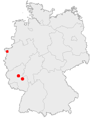
| Description | Ausgangspunkte und Siedlungsgebiet der "Pfälzer" am Niederrhein |
| Date | |
| Source | Image:Karte Bad Kreuznach in Deutschland.png, de:Bild:Karte Simmern Hunsrueck in Deutschland.png und Image:Lage der Stadt Goch in Deutschland.png |
| Author | Sven Tombers |
Licensing
This image was generated with OpenGeoDB. The information there is placed in the public domain, images generated from OpenGeoDB are derivative works without passing the threshold of creativity, they are therefore also public domain.
| This work is ineligible for copyright and therefore in the public domain because it consists entirely of information that is common property and contains no original authorship. |
File history
Click on a date/time to view the file as it appeared at that time.
| Date/Time | Thumbnail | Dimensions | User | Comment | |
|---|---|---|---|---|---|
| current | 08:17, 25 March 2024 | | 188 × 235 (6 KB) | 32X | Bei der damaligen Karte stimmten einige Grenzen nicht, bspw. von Berlin (um Spandau) und Hamburg |
| 05:25, 1 October 2006 |  | 188 × 235 (13 KB) | Zombi | {{Information |Description=Ausgangspunkte und Siedlungsgebiet der "Pfälzer" am Niederrhein |Source=:Image:Karte Bad Kreuznach in Deutschland.png, :[[Bild:Karte Simmern Hunsrueck in Deutschland.png]} und :[[Image:Lage der Stadt Goch in Deutschland.png |
File usage
The following pages on the English Wikipedia use this file (pages on other projects are not listed):
Global file usage
The following other wikis use this file:
- Usage on de.wikipedia.org
- Usage on pfl.wikipedia.org