
File:PanAmericanHwy.png

Size of this preview: 434 × 599 pixels. Other resolutions: 174 × 240 pixels | 348 × 480 pixels | 556 × 768 pixels | 742 × 1,024 pixels | 1,600 × 2,208 pixels.
Original file (1,600 × 2,208 pixels, file size: 2.08 MB, MIME type: image/png)
| This is a file from the Wikimedia Commons. Information from its description page there is shown below. Commons is a freely licensed media file repository. You can help. |

|
This road map image could be re-created using vector graphics as an SVG file. This has several advantages; see Commons:Media for cleanup for more information. If an SVG form of this image is available, please upload it and afterwards replace this template with
{{vector version available|new image name}}.
It is recommended to name the SVG file “PanAmericanHwy.svg”—then the template Vector version available (or Vva) does not need the new image name parameter. |
Summary
| Description |
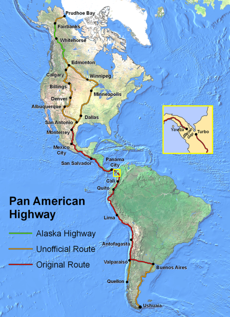
English: Route of the Pan-American Highway. Includes original route and unofficial extensions but doesn't reflect official designation of U.S. interstate highway system. Hotine Oblique Mercator Two Point Natural Origin Projection. |
| Source | Own work |
| Author | Created by en:User:Seaweege and released to PD |
Licensing

|
The copyright holder of this work allows anyone to use it for any purpose including unrestricted redistribution, commercial use, and modification.
Usage notes:
|
File history
Click on a date/time to view the file as it appeared at that time.
| Date/Time | Thumbnail | Dimensions | User | Comment | |
|---|---|---|---|---|---|
| current | 02:32, 18 January 2022 | | 1,600 × 2,208 (2.08 MB) | Natewich | Route of the Pan American Highway. Includes original route and unofficial extensions. Hotine Oblique Mercator Two Point Natural Origin Projection. Taken from en:Image:PanAmericanHwy.png. |
| 01:33, 27 November 2007 |  | 1,325 × 1,828 (3.72 MB) | Jabul | Route of the Pan American Highway. Includes original route and unofficial extensions. Hotine Oblique Mercator Two Point Natural Origin Projection. Taken from en:Image:PanAmericanHwy.png. | |
| 01:18, 27 November 2007 |  | 1,325 × 1,828 (3.72 MB) | Jabul | ||
| 02:36, 17 June 2007 |  | 1,325 × 1,828 (3.6 MB) | SchuminWeb | {{Information |Description=Route of the Pan American Highway. Includes original route and unofficial extensions. Hotine Oblique Mercator Two Point Natural Origin Projection |Source=Originally from [http://en.wikipedia.org en.wikipedia]; description page | |
| 15:26, 29 December 2006 |  | 1,700 × 2,200 (3.62 MB) | Chigliak | Original Description: Route of the Pan American Highway. Includes original route and unofficial extensions. Hotine Oblique Mercator Two Point Natural Origin Projection. Taken from en:Image:PanAmericanHwy.png. Created by en:User:Seaweege and rea |
File usage
The following pages on the English Wikipedia use this file (pages on other projects are not listed):
Global file usage
The following other wikis use this file:
- Usage on ar.wikipedia.org
- Usage on be-tarask.wikipedia.org
- Usage on be.wikipedia.org
- Usage on bg.wikipedia.org
- Usage on bn.wikipedia.org
- Usage on cs.wikipedia.org
- Usage on de.wikipedia.org
- Usage on de.wikivoyage.org
- Usage on el.wikipedia.org
- Usage on en.wikivoyage.org
- Usage on eo.wikipedia.org
- Usage on et.wikipedia.org
- Usage on eu.wikipedia.org
- Usage on fa.wikipedia.org
- Usage on fi.wikipedia.org
- Usage on fr.wikipedia.org
- Usage on he.wikipedia.org
- Usage on hi.wikibooks.org
- Usage on id.wikipedia.org
- Usage on it.wikipedia.org
- Usage on ja.wikipedia.org
- Usage on ka.wikipedia.org
- Usage on km.wikipedia.org
- Usage on ko.wikipedia.org
- Usage on lt.wikipedia.org
- Usage on ml.wikipedia.org
- Usage on mr.wikipedia.org
- Usage on ms.wikipedia.org
- Usage on nl.wikipedia.org
- Usage on no.wikipedia.org
- Usage on pl.wikipedia.org
- Usage on pt.wikipedia.org
- Usage on ro.wikipedia.org
View more global usage of this file.