
File:PIA00245 Baltis Vallis.jpg

Original file (2,150 × 2,150 pixels, file size: 1.99 MB, MIME type: image/jpeg)
| This is a file from the Wikimedia Commons. Information from its description page there is shown below. Commons is a freely licensed media file repository. You can help. |
Summary
| Description |
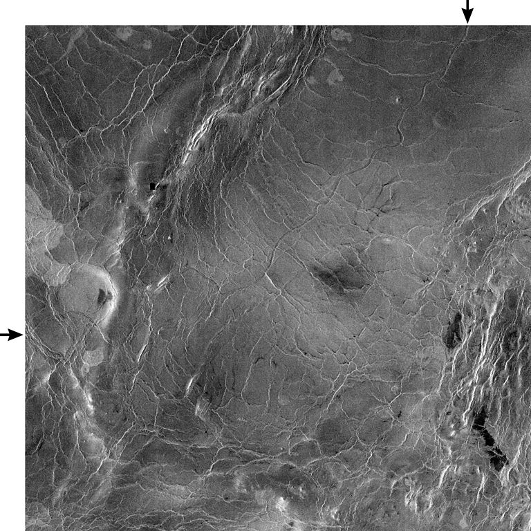
PIA00245: Venus - 600 Kilometer Segment of Longest Channel on Venus This compressed resolution radar mosaic from Magellan at 49 degrees north latitude, 165 degrees east longitude with dimensions of 460 by 460 kilometers (285 by 285 miles), shows a 600 kilometers (360 mile) segment of the longest channel discovered on Venus to date. The channel is approximately 1.8 kilometers (1.1 miles) wide. At more than 7,000 kilometers (4,200 miles) long, it is several hundred kilometers longer than the Nile River, Earth's longest river, thus making it the longest known channel in the solar system. Both ends of the channel are obscured, however, so its original length is unknown. The channel was initially discovered by the Soviet Venera 15-16 orbiters which, in spite of their one kilometer resolution, detected more than 1,000 kilometers (620 miles) of the channel. These channel-like features are common on the plains of Venus. In some places they appear to have been formed by lava which may have melted or thermally eroded a path over the plains' surface. Most are 1 to 3 kilometers (0.6 to 2 miles) wide. They resemble terrestrial meandering rivers in some aspects, with meanders, cutoff bows and abandoned channel segments. However, Venus channels are not as tightly sinuous as terrestrial rivers. Most are partly buried by younger lava plains, making their sources difficult to identify. A few have vast radar-dark plains units associated with them, suggesting large flow volumes. These channels, with large deposits appear to be older than other channel types, as they are crossed by fractures and wrinkle ridges, and are often buried by other volcanic materials. In addition, they appear to run both upslope and downslope, suggesting that the plains were warped by regional tectonism after channel formation. Resolution of the Magellan data is about 120 meters (400 feet). The white margins and arrows have been added to the NASA image. |
| Date | |
| Source | http://photojournal.jpl.nasa.gov/catalog/PIA00245 |
| Author | NASA/Jet Propulsion Lab |
This image or video was catalogued by Jet Propulsion Laboratory of the United States National Aeronautics and Space Administration (NASA) under Photo ID: PIA00245. This tag does not indicate the copyright status of the attached work. A normal copyright tag is still required. See Commons:Licensing. Other languages:
|
Licensing
| This file is in the public domain in the United States because it was solely created by NASA. NASA copyright policy states that "NASA material is not protected by copyright unless noted". (See Template:PD-USGov, NASA copyright policy page or JPL Image Use Policy.) | ||
 |
Warnings:
|
File history
Click on a date/time to view the file as it appeared at that time.
| Date/Time | Thumbnail | Dimensions | User | Comment | |
|---|---|---|---|---|---|
| current | 19:07, 8 December 2007 | | 2,150 × 2,150 (1.99 MB) | WolfmanSF | {{Information |Description=PIA00245: Venus - 600 Kilometer Segment of Longest Channel on Venus This compressed resolution radar mosaic from Magellan at 49 degrees north latitude, 165 degrees east longitude with dimensions of 460 by 460 kilometers (285 by |
File usage
Global file usage
The following other wikis use this file:
- Usage on fi.wikipedia.org
- Usage on fr.wikipedia.org
- Usage on gl.wikipedia.org
- Usage on hu.wikipedia.org
- Usage on it.wikipedia.org
- Usage on uk.wikipedia.org
- Usage on www.wikidata.org
- Usage on zh.wikipedia.org