
File:Old Alabama Capitol Tuscaloosa.jpg

Size of this preview: 800 × 590 pixels. Other resolutions: 320 × 236 pixels | 640 × 472 pixels | 1,024 × 756 pixels | 1,280 × 944 pixels | 2,560 × 1,889 pixels | 3,860 × 2,848 pixels.
Original file (3,860 × 2,848 pixels, file size: 1.73 MB, MIME type: image/jpeg)
| This is a file from the Wikimedia Commons. Information from its description page there is shown below. Commons is a freely licensed media file repository. You can help. |
Summary
| Description |
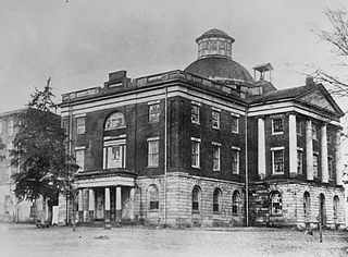
Per HABS datasheet: Old Alabama State Capitol, Broad Street, Tuscaloosa, Tuscaloosa County, AL.
|
||
| Date | |||
| Source |
Library of Congress, Prints and Photograph Division HABS: ALA,63-TUSLO,21-2
|
||
| Author | Unknown author |

| Camera location | | View this and other nearby images on: OpenStreetMap |
|---|
Licensing
| This image or media file contains material based on a work of a National Park Service employee, created as part of that person's official duties. As a work of the U.S. federal government, such work is in the public domain in the United States. See the NPS website and NPS copyright policy for more information. |
|
This media file is in the public domain in the United States. This applies to U.S. works where the copyright has expired, often because its first publication occurred prior to January 1, 1929, and if not then due to lack of notice or renewal. See this page for further explanation.
|
 | |
 |
This image might not be in the public domain outside of the United States; this especially applies in the countries and areas that do not apply the rule of the shorter term for US works, such as Canada, Mainland China (not Hong Kong or Macao), Germany, Mexico, and Switzerland. The creator and year of publication are essential information and must be provided. See Wikipedia:Public domain and Wikipedia:Copyrights for more details.
|
File history
Click on a date/time to view the file as it appeared at that time.
| Date/Time | Thumbnail | Dimensions | User | Comment | |
|---|---|---|---|---|---|
| current | 19:33, 18 January 2010 | | 3,860 × 2,848 (1.73 MB) | Martin H. | extracted from full size |
| 00:40, 30 November 2009 |  | 796 × 582 (380 KB) | Altairisfar | {{Information |Description={{en|Old Alabama State Capitol, Broad Street, Tuscaloosa, Tuscaloosa County, AL. Significance: Alabama State Capitol, 1829-1846; housed Alabama Central Female College after. / From 1825 to 1846, Tuscaloosa served as capital of |
File usage
The following pages on the English Wikipedia use this file (pages on other projects are not listed):