
File:Northern Ireland rail network sb.svg

Size of this PNG preview of this SVG file: 800 × 435 pixels. Other resolutions: 320 × 174 pixels | 640 × 348 pixels | 1,024 × 557 pixels | 1,280 × 697 pixels | 2,560 × 1,393 pixels | 2,275 × 1,238 pixels.
Original file (SVG file, nominally 2,275 × 1,238 pixels, file size: 453 KB)
| This is a file from the Wikimedia Commons. Information from its description page there is shown below. Commons is a freely licensed media file repository. You can help. |
Summary
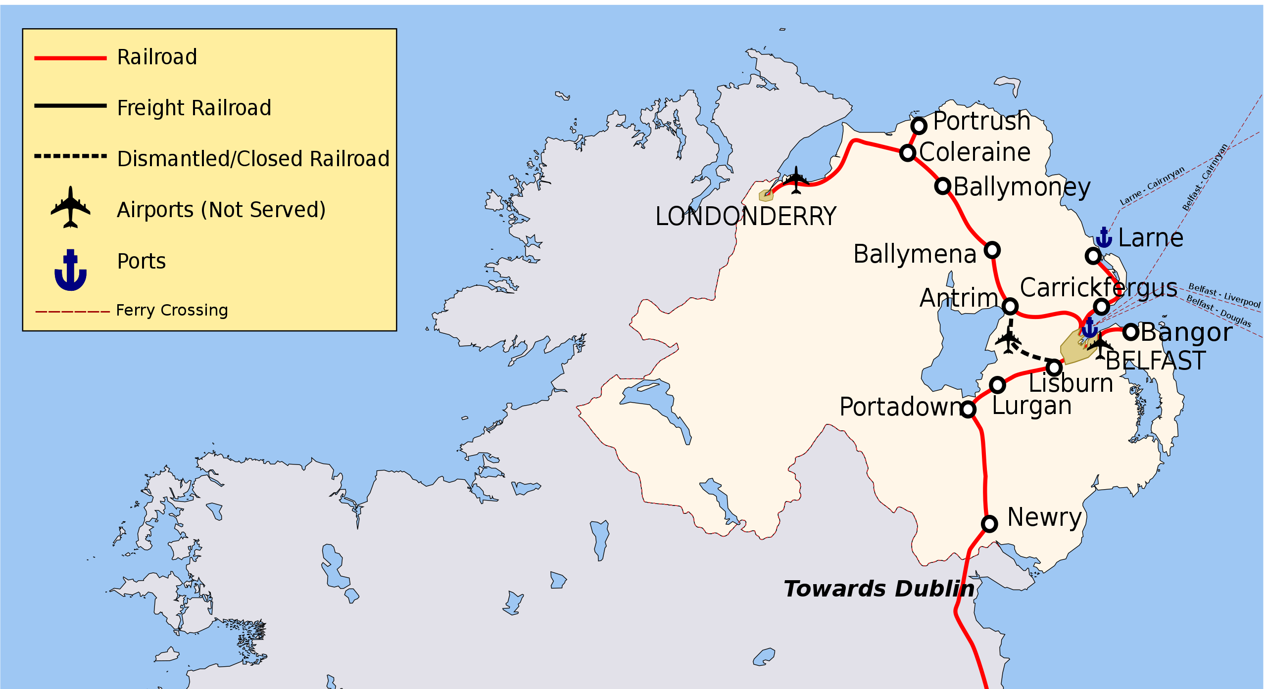
| Description | Map of Rail Networks in Northern Ireland. |
| Date | (UTC) |
| Source |
This file was derived from: Ireland rail network sb.svg:  |
| Author |
|
| Other versions |
[]
|

| This is a retouched picture, which means that it has been digitally altered from its original version. Modifications: Cropped. The original can be viewed here: Ireland rail network sb.svg:
|
Licensing
I, the copyright holder of this work, hereby publish it under the following licenses:
This file is licensed under the Creative Commons Attribution-Share Alike 3.0 Unported license.
- You are free:
- to share – to copy, distribute and transmit the work
- to remix – to adapt the work
- Under the following conditions:
- attribution – You must give appropriate credit, provide a link to the license, and indicate if changes were made. You may do so in any reasonable manner, but not in any way that suggests the licensor endorses you or your use.
- share alike – If you remix, transform, or build upon the material, you must distribute your contributions under the same or compatible license as the original.

|
Permission is granted to copy, distribute and/or modify this document under the terms of the GNU Free Documentation License, Version 1.2 or any later version published by the Free Software Foundation; with no Invariant Sections, no Front-Cover Texts, and no Back-Cover Texts. A copy of the license is included in the section entitled GNU Free Documentation License. |
You may select the license of your choice.
Original upload log
This image is a derivative work of the following images:
- File:Ireland_rail_network_sb.svg licensed with Cc-by-sa-3.0, GFDL
- 2012-03-02T15:58:58Z Jonto 2268x2801 (469301 Bytes) see http://en.wikipedia.org/wiki/Londonderry_railway_station Map was originally based on RoI data but updated with official NI data
- 2011-09-20T18:42:55Z Rwxrwxrwx 2268x2801 (481722 Bytes) reverted change to name of derry, see [[WP:DERRY]]
- 2010-07-01T11:52:40Z Classical geographer 2268x2801 (469301 Bytes) Since March 2010, the southern part of the [[:en:Western Railway Corridor|]] is open. Have changed that from projected (black dash) to current (red).
- 2010-06-11T01:37:49Z Jonto 2268x2801 (468758 Bytes) More accurate Antrim and Portadown line.
- 2010-06-11T00:48:52Z Jonto 2268x2801 (468301 Bytes) More accurate representation of Northern Ireland network, particularly for Larne line and derry line. More accurate location of airport and defunct line from Lisburn to airport marked as such.
- 2008-09-17T10:41:11Z Stabilo boss 2200x2800 (456823 Bytes)
- 2008-09-17T10:14:33Z Stabilo boss 2200x2800 (456728 Bytes)
- 2008-09-17T10:08:43Z Stabilo boss 2200x2800 (456424 Bytes) [[Category:Rail Transport in Ireland]] [[Category:Ireland]] [[Category:Maps of Ireland]]
- 2008-09-09T22:12:45Z Stabilo boss 2200x2800 (436218 Bytes) {{Information |Description= Map of Rail Networks in Ireland. |Source=Derivative Work using [[:Image:Ireland.svg]] and [[:Image:Ireland_rail_network.svg]] |Date=09 09 2008 |Author= [[User:Stabilo boss|Stabilo boss]] |Permissio
- 2008-09-09T22:07:45Z Stabilo boss 2200x2800 (409932 Bytes) {{Information |Description= Map of Rail Networks in Ireland. |Source=Derivative Work using [[:Image:Ireland.svg]] and [[:Image:Ireland_rail_network.svg]] |Date=09 09 2008 |Author= [[User:Stabilo boss|Stabilo boss]] |Permissio
Uploaded with derivativeFX
File history
Click on a date/time to view the file as it appeared at that time.
| Date/Time | Thumbnail | Dimensions | User | Comment | |
|---|---|---|---|---|---|
| current | 09:52, 23 September 2019 | | 2,275 × 1,238 (453 KB) | খাঁ শুভেন্দু | File uploaded using svgtranslate tool (https://tools.wmflabs.org/svgtranslate/). Added translation for bn. |
| 18:25, 18 May 2017 |  | 2,275 × 1,238 (463 KB) | RaviC | + Ferry interchanges, layout modifications | |
| 20:58, 24 December 2012 |  | 2,275 × 1,238 (451 KB) | RaviC | Fix text issue | |
| 11:39, 1 December 2012 |  | 2,275 × 1,238 (451 KB) | RaviC | == {{int:filedesc}} == {{Information |Description=Map of Rail Networks in Northern Ireland. |Source={{Derived from|Ireland_rail_network_sb.svg|display=50}} |Date=2012-12-01 11:38 (UTC) |Author=*File:Ireland_rail_network_sb.svg: [[User:Stabilo bos... |
File usage
The following pages on the English Wikipedia use this file (pages on other projects are not listed):
Global file usage
The following other wikis use this file:
- Usage on fr.wikipedia.org
- Usage on ga.wikipedia.org
- Usage on hu.wikipedia.org
- Usage on it.wikivoyage.org
- Usage on ru.wikipedia.org
- Usage on www.wikidata.org