
File:National Guardian Life Insurance Company Building, Gilman Street and Wisconsin Avenue, Mansion Hill, Madison, WI.jpg

Size of this preview: 800 × 600 pixels. Other resolutions: 320 × 240 pixels | 640 × 480 pixels | 1,024 × 768 pixels | 1,280 × 960 pixels | 2,560 × 1,920 pixels | 3,724 × 2,793 pixels.
Original file (3,724 × 2,793 pixels, file size: 3.67 MB, MIME type: image/jpeg)
| This is a file from the Wikimedia Commons. Information from its description page there is shown below. Commons is a freely licensed media file repository. You can help. |
Summary
| Description |
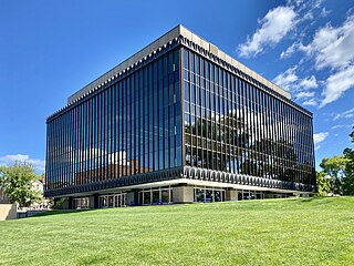
English: Built in 1964-1965, this International Style Modern office building has surprisingly little information available about it. The building replaced the historic Vilas mansion, home to several notable early and prominent citizens of Madison, and a favorite building of Frank Lloyd Wright. The demolition of the mansion and construction of this building catalyzed the creation of the historic preservation movement in Madison and the state of Wisconsin, as it was massively out of scale with the surrounding buildings and the loss of a historical landmark as significant as the Vilas House made many in the community realize the need to protect the city’s historic resources. The building features a glass curtain wall, seemingly inspired by Ludwig Mies van der Rohe, sandwiched between a parapet and floor structure clad in metal panels with a trapezoid geometric motif at the top and bottom, which is seemingly inspired by Frank Lloyd Wright, a recessed first floor with Le Corbusier-inspired pilotis, or exposed columns, around the perimeter of the floor, framing storefronts, and clad in stone panels, a penthouse with an oversized cap, exposed columns, and stone panel cladding, a low-slope roof, and a large lawn to the side and rear, which conceals the building’s underground parking garage. The building, despite being a quite excellent example of mid-20th Century modern architecture, is a noncontributing structure in the Mansion Hill Historic District, listed on the National Register of Historic Places in 1997. The building’s architecture seems to have escaped notice by the local architectural historian and history groups despite being a quite well-designed International Style building. |
| Date | |
| Source | https://www.flickr.com/photos/59081381@N03/52763323555/ |
| Author | w_lemay |
| Camera location | | View this and other nearby images on: OpenStreetMap |
|---|
Licensing
This file is licensed under the Creative Commons Attribution-Share Alike 2.0 Generic license.
- You are free:
- to share – to copy, distribute and transmit the work
- to remix – to adapt the work
- Under the following conditions:
- attribution – You must give appropriate credit, provide a link to the license, and indicate if changes were made. You may do so in any reasonable manner, but not in any way that suggests the licensor endorses you or your use.
- share alike – If you remix, transform, or build upon the material, you must distribute your contributions under the same or compatible license as the original.
| This image was originally posted to Flickr by w_lemay at https://flickr.com/photos/59081381@N03/52763323555. It was reviewed on 22 March 2023 by FlickreviewR 2 and was confirmed to be licensed under the terms of the cc-by-sa-2.0. |
File history
Click on a date/time to view the file as it appeared at that time.
| Date/Time | Thumbnail | Dimensions | User | Comment | |
|---|---|---|---|---|---|
| current | 18:12, 22 March 2023 | | 3,724 × 2,793 (3.67 MB) | Ser Amantio di Nicolao | Uploaded a work by w_lemay from https://www.flickr.com/photos/59081381@N03/52763323555/ with UploadWizard |
File usage
The following pages on the English Wikipedia use this file (pages on other projects are not listed):
Global file usage
The following other wikis use this file:
- Usage on de.wikipedia.org
- Usage on www.wikidata.org