
File:Nansen Fram Map.png
No higher resolution available.
Nansen_Fram_Map.png (800 × 479 pixels, file size: 195 KB, MIME type: image/png)
| This is a file from the Wikimedia Commons. Information from its description page there is shown below. Commons is a freely licensed media file repository. You can help. |
Summary
| Description |
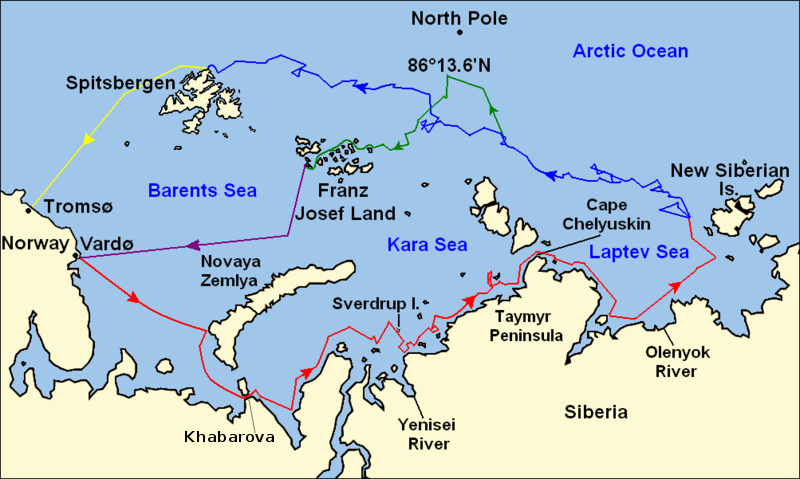
Map of the Arctic Ocean showing the routes taken during the 1893–96 Nansen's Fram expedition: Fram's route eastward from Vardø to the Siberian coast, turning north at the New Siberian Islands to enter the pack ice. July – September 1893 Fram's drift in the ice from the New Siberian Islands, north and west to Spitsbergen, September 1893 – August 1896 Nansen and Johansen's march to Farthest North, 86°20'N, and their subsequent retreat to Cape Flora in Franz Josef Land. February 1895 – June 1896 Nansen and Johansen's return to Vardø from Cape Flora, August 1896 Fram's voyage from Spitsbergen to Tromsø, August 1896 |
| Date | |
| Source | Base map of European and Asian mainland is from File:Map of Russian Subjects old.png by User:fremantleboy, map of Spitsbergen (Svalbard) is based on File:Bjornoya map.png by User:NormanEinstein. Voyage traces based on this map from The Northern Lights Route. First published in Nansen, Fridtjof: Farthest North, Constable & Co, London 1897 |
| Author | User:fremantleboy, User:NormanEinstein, Ruhrfisch |
| Permission (Reusing this file) |
GFDL, CC-BY-SA |
| Other versions |
|


|
File:Nansen Fram Map.svg is a vector version of this file. It should be used in place of this PNG file when not inferior.
File:Nansen Fram Map.png → File:Nansen Fram Map.svg
For more information, see Help:SVG. |
 |
Licensing
I, the copyright holder of this work, hereby publish it under the following licenses:

|
Permission is granted to copy, distribute and/or modify this document under the terms of the GNU Free Documentation License, Version 1.2 or any later version published by the Free Software Foundation; with no Invariant Sections, no Front-Cover Texts, and no Back-Cover Texts. A copy of the license is included in the section entitled GNU Free Documentation License. |
This file is licensed under the Creative Commons Attribution-Share Alike 4.0 International, 3.0 Unported, 2.5 Generic, 2.0 Generic and 1.0 Generic license.
- You are free:
- to share – to copy, distribute and transmit the work
- to remix – to adapt the work
- Under the following conditions:
- attribution – You must give appropriate credit, provide a link to the license, and indicate if changes were made. You may do so in any reasonable manner, but not in any way that suggests the licensor endorses you or your use.
- share alike – If you remix, transform, or build upon the material, you must distribute your contributions under the same or compatible license as the original.
You may select the license of your choice.
File history
Click on a date/time to view the file as it appeared at that time.
| Date/Time | Thumbnail | Dimensions | User | Comment | |
|---|---|---|---|---|---|
| current | 12:16, 8 May 2011 | | 800 × 479 (195 KB) | Chris55 | Added [http://website.lineone.net/~polar.publishing/khabarova.htm Khabarova] where they picked up the dogs. |
| 15:50, 21 October 2009 |  | 1,003 × 601 (78 KB) | Ruhrfisch | Make arrowheads less triangular (indentations at rear) | |
| 15:23, 21 October 2009 |  | 1,003 × 601 (78 KB) | Ruhrfisch | Add arrowheads per FAC | |
| 18:50, 20 October 2009 |  | 1,003 × 601 (78 KB) | Ruhrfisch | Make magenta line purple | |
| 13:36, 11 October 2009 |  | 1,003 × 601 (78 KB) | Ruhrfisch | Yellow line for orange, some labels smaller, Farthest North replaced with actual figure, all other info the same | |
| 03:08, 11 October 2009 |  | 1,003 × 601 (80 KB) | Ruhrfisch | Darker green for that line, all other information is the same | |
| 02:46, 11 October 2009 |  | 1,003 × 601 (80 KB) | Ruhrfisch | Added last two lines for ice voyages, added last labels, all other information the same. | |
| 19:30, 9 October 2009 |  | 1,003 × 601 (73 KB) | Ruhrfisch | Add labels, two more voyage lines, all other information is the same | |
| 16:12, 9 October 2009 |  | 1,003 × 601 (57 KB) | Ruhrfisch | == Summary == {{Information |Description = Map of the Arctic Ocean showing the path of Nansen's Fram expedition 1893 to 1896 |Source = Base map of European mainland is from [[:File:Map of Russian Subjects old.png] |
File usage
The following pages on the English Wikipedia use this file (pages on other projects are not listed):
Global file usage
The following other wikis use this file:
- Usage on bg.wikipedia.org
- Usage on es.wikipedia.org
- Usage on fr.wikipedia.org
- Usage on hr.wikipedia.org
- Usage on id.wikipedia.org
- Usage on ja.wikipedia.org
- Usage on pt.wikipedia.org
- Usage on sl.wikipedia.org