
File:Nabucco Gas Pipeline-en.svg

Size of this PNG preview of this SVG file: 800 × 436 pixels. Other resolutions: 320 × 175 pixels | 640 × 349 pixels | 1,024 × 559 pixels | 1,280 × 698 pixels | 2,560 × 1,396 pixels.
Original file (SVG file, nominally 1,100 × 600 pixels, file size: 227 KB)
| This is a file from the Wikimedia Commons. Information from its description page there is shown below. Commons is a freely licensed media file repository. You can help. |
Summary
| Description |
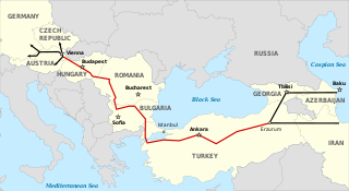
Deutsch: Route der Nabucco-Pipeline, vom Kaspischen Meer nach West-Europa. Nabucco-Pipeline Andere Gas-Pipelines English: Path of the Nabucco pipeline, between the Caspian Sea and Western Europe. It get round Russia. Nabucco Gas pipeline Other Gas pipeline Español: 1=Recorrido del Gasoducto Nabucco, entre el mar Caspio y Europa Occidental. Gasoducto Nabucco Otros gasoductos Français : Tracé du gazoduc Nabucco, entre la mer Caspienne et l'Europe occidentale. Il évite le passage par la Russie. Gazoduc Nabucco Autres gazoducs Magyar: A Nabucco földgázvezeték tervezett nyomvonala a Kaszpi-tenger és Nyugat-Európa között. A vezeték megkerüli Oroszországot. A Nabucco gázvezeték Más gázvezetékek Български: Път на газопровода Набуко между Каспийско море и Западна Европа. Газопроводът заобикаля Русия. Газопровод Набуко Друг газопровод Русский: Маршрут газопровод Набукко, из Каспийского моря в Зап. Европу. Не проходит по территории России. газопровод Набукко другие газопроводы Српски / srpski: Траса гасовода Набуко од Каспијског језера до западне Европе. Гасовод "Набуко" Други гасоводи Українська: Шлях газопроводу Nabucco від Каспійського моря до західної Європи оминаючи Росію. Газопровід Nabucco Інші газопроводи ქართული: ნაბუქოს გაზსადენის მარშრტური კასპიის ზღვასა და დასავლეთ ევროპას შორის, რომელიც გვერდს უვლის რუსეთს. ნაბუქოს გაზსადენი სხვა გაზსადენები |
||
| Date | (UTC) | ||
| Source | Nabucco Gas Pipeline-fr.svg | ||
| Author | |||
| Other versions |
[]
|
||
| SVG development |
|
| Camera location | | View this and other nearby images on: OpenStreetMap |
|---|
Licensing
I, the copyright holder of this work, hereby publish it under the following licenses:
| Copyleft: This work of art is free; you can redistribute it and/or modify it according to terms of the Free Art License. You will find a specimen of this license on the Copyleft Attitude site as well as on other sites. |
This file is licensed under the Creative Commons Attribution-Share Alike 4.0 International, 3.0 Unported, 2.5 Generic, 2.0 Generic and 1.0 Generic license.
- You are free:
- to share – to copy, distribute and transmit the work
- to remix – to adapt the work
- Under the following conditions:
- attribution – You must give appropriate credit, provide a link to the license, and indicate if changes were made. You may do so in any reasonable manner, but not in any way that suggests the licensor endorses you or your use.
- share alike – If you remix, transform, or build upon the material, you must distribute your contributions under the same or compatible license as the original.
You may select the license of your choice.
Original upload log
This image is a derivative work of the following images:
- File:Nabucco Gas Pipeline-fr.svg licensed with Cc-by-sa-3.0,2.5,2.0,1.0, GFDL
- 2008-01-31T19:05:37Z Sémhur 1100x600 (222425 Bytes) == Description == {{Information |Description= {{en|Path of the [[:en:Nabucco Pipeline|Nabucco pipeline]], between the Caspian Sea and Western Europe. It get round Russia.}} {{fr|Tracé du [[:fr:Nabucco (gazoduc)|gazoduc Nabuc
Uploaded with derivativeFX
File history
Click on a date/time to view the file as it appeared at that time.
| Date/Time | Thumbnail | Dimensions | User | Comment | |
|---|---|---|---|---|---|
| current | 12:08, 3 October 2023 | | 1,100 × 600 (227 KB) | KajenCAT | File uploaded using svgtranslate tool (https://svgtranslate.toolforge.org/). Added translation for ca. |
| 18:08, 14 July 2009 |  | 1,100 × 600 (213 KB) | Sémhur | Misspelling : Caspain => Caspain ; fonts Arial => DejaVu Sans Condensed and Times New Roman => DejaVu Serif Condensed ; new standard colors. | |
| 20:16, 21 February 2009 |  | 1,100 × 600 (217 KB) | Ahruman | {{Information |Description={{en|Path of the Nabucco pipeline, between the Caspian Sea and Western Europe. It get round Russia.}} {{legend-line|red solid 2px| Nabucco Gas pipeline}} {{legend-line|black solid 2px| Other Ga |
File usage
The following pages on the English Wikipedia use this file (pages on other projects are not listed):
Global file usage
The following other wikis use this file:
- Usage on az.wikipedia.org
- Usage on bg.wikipedia.org
- Usage on ca.wikipedia.org
- Usage on el.wikipedia.org
- Usage on fa.wikipedia.org
- Usage on fi.wikipedia.org
- Usage on he.wikipedia.org
- Usage on it.wikipedia.org
- Usage on ko.wikipedia.org
- Usage on nl.wikipedia.org
- Usage on pt.wikipedia.org
- Usage on ro.wikipedia.org
- Usage on ro.wikinews.org
- Usage on tr.wikipedia.org
- Usage on uk.wikipedia.org