
File:Mohican distribution map.svg

Original file (SVG file, nominally 1,121 × 1,277 pixels, file size: 696 KB)
![]() ✓
The source code of this SVG is valid.
✓
The source code of this SVG is valid.
| Description |
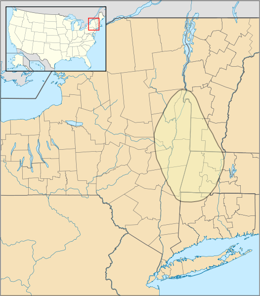
Approximate range of Mohican (Mahican) native americans |
|---|---|
| Source |
Self created using Inkscape. Map outline is a composite of file:US Locator Blank2.svg (Originally uploaded at English Wikipedia by en:User:Papayoung and en:User:Ilmari Karonen, modified by NordNordWest at Commons. Originally created by en:User:Wapcaplet), file:USA New York location map.svg{NordNordWest at Commons), file:USA Vermont location map.svg (Alexrk2 at Commons), file:USA Massachusetts location map.svg (Alexrk2 at Commons) and file:USA Connecticut location map.svg (Alexrk2 at Commons). The map data for the Mohican range was obtained from Native Languages of the Americas, "Mohican Culture and History" and the various map sub-pages there. |
| Date |
12th July 2009 |
| Author | |
| Permission (Reusing this file) |
See below.
|
Licensing[edit]
| This work is licensed under the Creative Commons Attribution-ShareAlike 3.0 License. Attribution: Courtesy Spinningspark at Wikipedia |
| The uploader or another editor requests that a local copy of this file be kept. This image or media file may be available on the Wikimedia Commons as File:Mohican distribution map.svg. While the license of this file may be compliant with the Wikimedia Commons, an editor has requested that the local copy be kept too. This file does not meet CSD F8 and should not be tagged as a Commons duplicate. If you desire to nominate it for deletion, notify the tagging editor. |
File history
Click on a date/time to view the file as it appeared at that time.
| Date/Time | Thumbnail | Dimensions | User | Comment | |
|---|---|---|---|---|---|
| current | 21:40, 12 July 2009 | | 1,121 × 1,277 (696 KB) | Spinningspark (talk | contribs) | {{Information |Description=Approximate range of Mohican (Mahican) native americans |Source=Self created using Inkscape. Map outline is a composite of file:US Locator Blank2.svg (Originally uploaded at English Wikipedia by en:User:Papayoung and en:Us |
You cannot overwrite this file.
File usage
The following file is a duplicate of this file (more details):
- File:Mohican distribution map.svg from Commons