
File:Moghulistan.PNG

Size of this preview: 800 × 372 pixels. Other resolutions: 320 × 149 pixels | 640 × 298 pixels | 1,075 × 500 pixels.
Original file (1,075 × 500 pixels, file size: 995 KB, MIME type: image/png)
| This is a file from the Wikimedia Commons. Information from its description page there is shown below. Commons is a freely licensed media file repository. You can help. |
Summary
| Description |
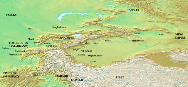
English: Map of Central Asia — in 1450 CE.
Español: Asia Central en el año 1450 dC |
| Date | |
| Source |
Own work (Original caption: " Own work. ") Data sources : * Background map : Topographic map#Global 1-kilometer map (SRTM3 v.2) (public domain) ** Elias, N. Commentary. The Tarikh-i-Rashidi (A History of the Moghuls of Central Asia). By Mirza Muhammad Haidar. Translated by Edward Denison Ross, edited by N. Elias. London, 1895. |
| Author | Ro4444 at en.wikipedia |
Licensing
Ro4444 at en.wikipedia, the copyright holder of this work, hereby publishes it under the following licenses:
This file is licensed under the Creative Commons Attribution-Share Alike 3.0 Unported license.
Attribution: Ro4444 at en.wikipedia
- You are free:
- to share – to copy, distribute and transmit the work
- to remix – to adapt the work
- Under the following conditions:
- attribution – You must give appropriate credit, provide a link to the license, and indicate if changes were made. You may do so in any reasonable manner, but not in any way that suggests the licensor endorses you or your use.
- share alike – If you remix, transform, or build upon the material, you must distribute your contributions under the same or compatible license as the original.

|
Permission is granted to copy, distribute and/or modify this document under the terms of the GNU Free Documentation License, Version 1.2 or any later version published by the Free Software Foundation; with no Invariant Sections, no Front-Cover Texts, and no Back-Cover Texts. A copy of the license is included in the section entitled GNU Free Documentation License. |
You may select the license of your choice.
Original upload log
The original description page was here. All following user names refer to en.wikipedia.
- 2011-07-18 02:04 Ro4444 1075×500× (1019369 bytes) == Description == {{Information |Description= {{en| Central Asia in 1450 AD}} |Source=Own work. {{clr}} Data sources : * Background map : [[Topographic map#Global 1-kilometer map]] (SRTM3 v.2) (public domain){{clr}} * Map boundaries are based off multiple sources: ** Elias, N. Commentary. ''The Tarikh-i-Rashidi (A History of the Moghuls of Central Asia)''. By Mirza Muhammad Haidar. Translated by Edward Denison Ross, edited by N. Elias. London, 1895. |Date=2011-07-17 |Author= [[User:ro4444|ro4444]] |Permission= }}
- 2007-08-10 22:28 Ro4444 715×330× (270646 bytes) The Moghul Khaganate and surrounding countries at the beginning of 1450 AD. Ruler names are directly under dynastic names.
File history
Click on a date/time to view the file as it appeared at that time.
| Date/Time | Thumbnail | Dimensions | User | Comment | |
|---|---|---|---|---|---|
| current | 03:04, 18 July 2011 | | 1,075 × 500 (995 KB) | OgreBot | (BOT): Uploading old version of file from en.wikipedia; originally uploaded on 2011-07-18 02:04:38 by Ro4444 |
| 00:46, 26 February 2011 |  | 715 × 330 (264 KB) | MALLUS | {{Information |Description= Mapa de Mogolistan |Source= English Wikipedia |Date= 2007 |Author= User:Ro4444 |Permission= {{GFDL}} |other_versions= No }} Category:History of China by area |
File usage
The following pages on the English Wikipedia use this file (pages on other projects are not listed):
Global file usage
The following other wikis use this file:
- Usage on ar.wikipedia.org
- Usage on ast.wikipedia.org
- Usage on azb.wikipedia.org
- Usage on ca.wikipedia.org
- Usage on de.wikipedia.org
- Usage on es.wikipedia.org
- Usage on et.wikipedia.org
- Usage on fa.wikipedia.org
- Usage on fr.wikipedia.org
- Usage on it.wikipedia.org
- Usage on ja.wikipedia.org
- Usage on kk.wikipedia.org
- Usage on lt.wikipedia.org
- Usage on mk.wikipedia.org
- Usage on mn.wikipedia.org
- Usage on ms.wikipedia.org
- Usage on nl.wikipedia.org
- Usage on pnb.wikipedia.org
- Usage on ru.wikipedia.org
- Usage on ur.wikipedia.org
- Usage on uz.wikipedia.org
- Usage on vi.wikipedia.org
- Usage on www.wikidata.org
- Usage on zh.wikipedia.org