
File:Mill Bridge 1903.jpg
Size of this preview: 800 × 595 pixels. Other resolutions: 320 × 238 pixels | 640 × 476 pixels | 906 × 674 pixels.
Original file (906 × 674 pixels, file size: 127 KB, MIME type: image/jpeg)
| This is a file from the Wikimedia Commons. Information from its description page there is shown below. Commons is a freely licensed media file repository. You can help. |
Summary
| Description |
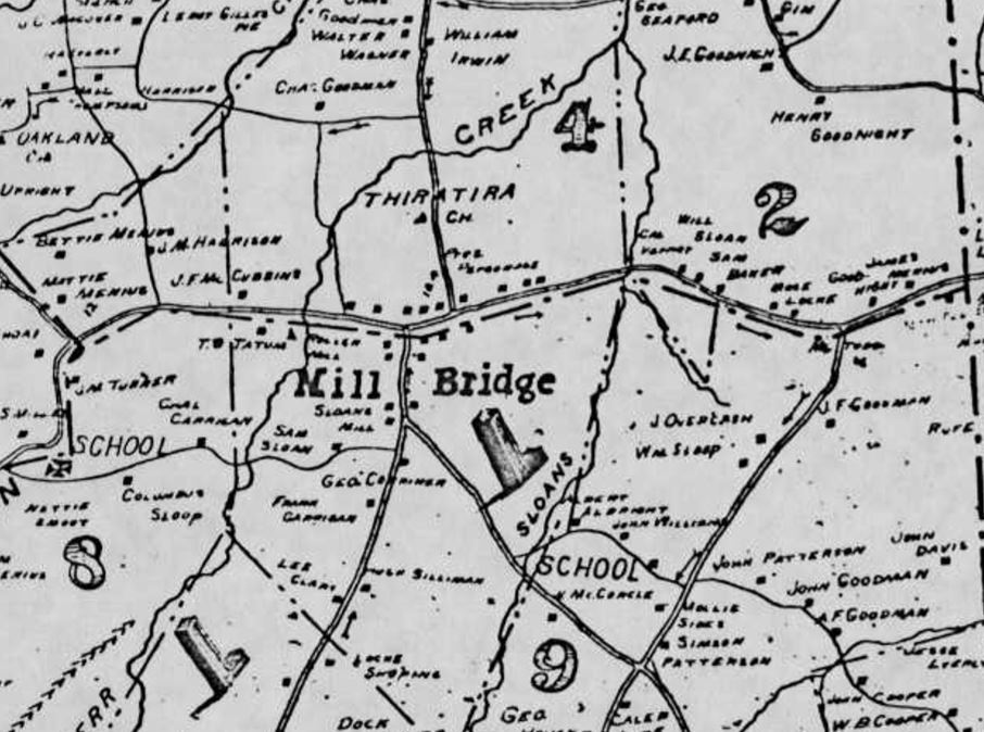
English: Region of Rowan County, North Carolina called Mill Bridge in 1903 as depicted in C. M. Miller's map. Referenced in the 1979 study,
Kerr Mill and the Mill Bridge Community, Rowan County by Bruce S. Cheeseman |
| Date | |
| Source | http://digital.ncdcr.gov/cdm/ref/collection/p16062coll6/id/8433 North Carolina State Library Digital Collection, cut and paste |
| Author | C. M. Miller's 1903 Map of Mill Bridge region in Rowan County, North Carolina |
| Camera location | | View this and other nearby images on: OpenStreetMap |
|---|
locations of houses, churches, streams, and mills indicated
Licensing
|
This work is in the public domain in its country of origin and other countries and areas where the copyright term is the author's life plus 70 years or fewer. This work is in the public domain in the United States because it was published (or registered with the U.S. Copyright Office) before January 1, 1929. | |
| This file has been identified as being free of known restrictions under copyright law, including all related and neighboring rights. | |
File history
Click on a date/time to view the file as it appeared at that time.
| Date/Time | Thumbnail | Dimensions | User | Comment | |
|---|---|---|---|---|---|
| current | 18:28, 6 July 2019 | | 906 × 674 (127 KB) | G. Moore | User created page with UploadWizard |
File usage
The following pages on the English Wikipedia use this file (pages on other projects are not listed):