
File:Michigan Left.svg

Original file (SVG file, nominally 1,045 × 426 pixels, file size: 24 KB)
| This is a file from the Wikimedia Commons. Information from its description page there is shown below. Commons is a freely licensed media file repository. You can help. |
Summary
| Description |
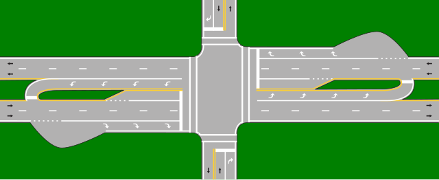
English: Excessively detailed diagram of a Michigan Left intersection. Based on MI Left on narrow blvd.JPG and FHWA MUTCD diagrams. |
| Date | |
| Source | Own work based on: MI Left on narrow blvd.JPG |
| Author | Nandhp |
| Other versions | MI Left on narrow blvd.JPG |
| SVG development | This diagram was created with Inkscape. |
Description from MI Left on narrow blvd.JPG
Author: I am the author -- Wikipedia editor User:Don'tKnowItAtAll. I lived in Michigan and am a registered professional engineer in Michigan. source: The image was created over several days in Jun 2008 using MSPaint and saving as jpeg; minor final editing using MS Photo Editor. The image is a stylized representation of the intersection of US31 and Robbins Rd in Grand Haven Michigan (rotated 90 degrees) but is representative of a lot of narrow boulevard. Michigan Lefts found in SW Michigan (as indicated on the Talk:Michigan left article page). basic info: shows a narrow boulevard with the addition of a Michigan Left. It is not intended to be a scalable picture but rather used for graphic depictions of a controversial application of a Michigan Left. Don'tKnowItAtAll (talk) 19:33, 16 June 2008 (UTC)
Licensing
- You are free:
- to share – to copy, distribute and transmit the work
- to remix – to adapt the work
- Under the following conditions:
- attribution – You must give appropriate credit, provide a link to the license, and indicate if changes were made. You may do so in any reasonable manner, but not in any way that suggests the licensor endorses you or your use.
- share alike – If you remix, transform, or build upon the material, you must distribute your contributions under the same or compatible license as the original.

|
Permission is granted to copy, distribute and/or modify this document under the terms of the GNU Free Documentation License, Version 1.2 or any later version published by the Free Software Foundation; with no Invariant Sections, no Front-Cover Texts, and no Back-Cover Texts. A copy of the license is included in the section entitled GNU Free Documentation License. |
File history
Click on a date/time to view the file as it appeared at that time.
| Date/Time | Thumbnail | Dimensions | User | Comment | |
|---|---|---|---|---|---|
| current | 00:57, 15 June 2010 | 1,045 × 426 (24 KB) | Nandhp | {{Information |Description={{en|1=Excessively detailed diagram of a en:Michigan Left intersection. Based on en:File:MI_Left_on_narrow_blvd.JPG and FHWA MUTCD diagrams.}} |Source={{own}} |Author=Nandhp |Date=2010-06-14 |Permission |
File usage
Global file usage
The following other wikis use this file:
- Usage on de.wikipedia.org
- Usage on fr.wikipedia.org
- Usage on ja.wikipedia.org
- Usage on nl.wikipedia.org