
File:Mesosaurus sea.png

Size of this preview: 718 × 600 pixels. Other resolutions: 287 × 240 pixels | 575 × 480 pixels | 920 × 768 pixels | 1,226 × 1,024 pixels | 2,008 × 1,677 pixels.
Original file (2,008 × 1,677 pixels, file size: 1.39 MB, MIME type: image/png)
| This is a file from the Wikimedia Commons. Information from its description page there is shown below. Commons is a freely licensed media file repository. You can help. |
Summary
| Description |
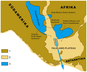
English: Paleogeographic map showing distribution of sediments of Lower Permian Gondwanan epicontinetal sea or lake ("Mesosaurus Sea") in the Paraná and Karoo Basins of South America and southern Africa. Legend: 1 = emerged surface of present day continents; 2 = submerged areas of present day continents (present day shelf areas); 3 = distribution of mesosaur bearing strata (Whitehill, Irati, and Mangrullo Formations) in outcrop and subsurface of present day land masses. Modified from Oelofsen & Araújo (1987).[1]
Deutsch: Paläogeographische Karte mit Verbreitung der Ablagerungen des unterpermischen gondwanischen Epikontinentalmeeres oder Sees ("Mesosaurus-Meer") im Paraná-Becken Südamerikas und den Karoo-Becken des südlichen Afrikas. Legende: 1 = trockenliegende Fläche der heutigen Kontinente; 2 = vom Meer bedeckte Gebiete der heutigen Kontinente (heutige Schelf-Gebiete); 3 = Verbreitung der Mesosaurier-führenden Schichten (Whitehill-, Irati- und Mangrullo-Formation) in Tagesaufschlüssen und im Untergrund der heutigen Landmassen. Verändert aus Oelofsen & Araújo (1987).[1] |
| Date | |
| Source | Own work |
| Author | Gretarsson |
References
- ↑ a b Burger W. Oelofsen, Dina C. Araújo (1987): Mesosaurus tenuidens and Stereosternum tumidum from the Permian Gondwana of both Southern Africa and South America. South African Journal of Science, 83, pp. 370-372
Licensing
I, the copyright holder of this work, hereby publish it under the following licenses:

|
Permission is granted to copy, distribute and/or modify this document under the terms of the GNU Free Documentation License, Version 1.2 or any later version published by the Free Software Foundation; with no Invariant Sections, no Front-Cover Texts, and no Back-Cover Texts. A copy of the license is included in the section entitled GNU Free Documentation License. |
This file is licensed under the Creative Commons Attribution-Share Alike 3.0 Unported, 2.5 Generic, 2.0 Generic and 1.0 Generic license.
- You are free:
- to share – to copy, distribute and transmit the work
- to remix – to adapt the work
- Under the following conditions:
- attribution – You must give appropriate credit, provide a link to the license, and indicate if changes were made. You may do so in any reasonable manner, but not in any way that suggests the licensor endorses you or your use.
- share alike – If you remix, transform, or build upon the material, you must distribute your contributions under the same or compatible license as the original.
You may select the license of your choice.
File history
Click on a date/time to view the file as it appeared at that time.
| Date/Time | Thumbnail | Dimensions | User | Comment | |
|---|---|---|---|---|---|
| current | 14:33, 20 December 2012 | | 2,008 × 1,677 (1.39 MB) | Gretarsson | {{Information |Description ={{en|1=Paleogeographic map showing distribution of sediments of Lower Permian Gondwanan epicontinetal sea or lake ("Mesosaurus Sea") in the Paraná and Karoo Basins of South America and southern Africa. Legend: 1 = emerge... |
File usage
The following pages on the English Wikipedia use this file (pages on other projects are not listed):
Global file usage
The following other wikis use this file:
- Usage on de.wikipedia.org
- Usage on ja.wikipedia.org