
File:Map of Woodbridge, Ontario, 1878.jpg
Size of this preview: 696 × 599 pixels. Other resolutions: 279 × 240 pixels | 557 × 480 pixels | 720 × 620 pixels.
Original file (720 × 620 pixels, file size: 255 KB, MIME type: image/jpeg)
| This is a file from the Wikimedia Commons. Information from its description page there is shown below. Commons is a freely licensed media file repository. You can help. |
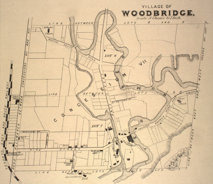
| Description | A map depicting the western half of lots 7 and 8 of Concession VII in Woodbridge, a community in York County, Ontario. On the left, the rail line Toronto Grey and Bruce Railway is labelled. A western branch of the Humber River is prominent. |
| Date | |
| Source | Illustrated Historical Atlas of County York (from McGill Digital Library County Atlas) |
| Author | Miles & Co. |
| This Canadian work is in the public domain in Canada because its creator died prior to January 1, 1972.
|
 | |
|
| ||
File history
Click on a date/time to view the file as it appeared at that time.
| Date/Time | Thumbnail | Dimensions | User | Comment | |
|---|---|---|---|---|---|
| current | 20:03, 23 November 2007 | | 720 × 620 (255 KB) | Mindmatrix | {{Information |Description = Map of Woodbridge, in York County, Ontario |Source = Illustrated Historical Atlas of County York (from [http://digital.library.mcgill.ca/countyatlas/showtown2.php?TownID=Woodbridge McGill Digital Library County Atla |
File usage
The following pages on the English Wikipedia use this file (pages on other projects are not listed):
Global file usage
The following other wikis use this file:
- Usage on es.wikipedia.org