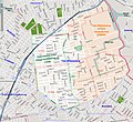
File:Map of East Williamsburg (2009).jpg

Page contents not supported in other languages.
This is a file from the Wikimedia Commons
From Wikipedia, the free encyclopedia

Original file(991 × 910 pixels, file size: 831 KB, MIME type: image/jpeg)

Summary

Description
English: The East Williamsburg section of Brooklyn, NY, is shown in highlight in the center of the map. There is no official definition of the East Williamsburg boundaries, so this map serves only as a guide. The original 3rd District of the Village of Williamsburg, annexed to Williamsburg in 1835, is shown in light green. The East Williamsburg In-Place Industrial Park (EWIPIP), as defined by the City of New York, is shown in light orange. The lavender line that follows Flushing Avenue, from left to right on the map, denotes the border between Community District 1 (to the North) and Community District 4 to the South. Postal districts are delineated by light red lines, with ZIP Codes given in light red font.

The boundaries of the 3rd district can be found in "A Map of Williamsburgh", Isaac Vieth, Brooklyn, 1845. "The Village is divided into three districts, numbered one two and three. All west of the centre of Union Ave and south of the centre of Grand Street composes the first district; all west of Union Avenue and to the north of Grand Street composes the Second District; and all east of Union Avenue, the Third District."

The boundaries of the East Williamsburg In-Place Industrial Park (EWIPIP) are defined by the City of New York and can be found, for example, at Map of CD1 Industrial Study Areas.
Date
Source OpenStreetMap
Author OpenStreetMap

Licensing

w:en:Creative Commons
attribution share alike
This file is licensed under the Creative Commons Attribution-Share Alike 3.0 Unported license.
You are free:
  • to share – to copy, distribute and transmit the work
  • to remix – to adapt the work
Under the following conditions:
  • attribution – You must give appropriate credit, provide a link to the license, and indicate if changes were made. You may do so in any reasonable manner, but not in any way that suggests the licensor endorses you or your use.
  • share alike – If you remix, transform, or build upon the material, you must distribute your contributions under the same or compatible license as the original.

Captions

Add a one-line explanation of what this file represents

Items portrayed in this file

depicts

3 May 2009

image/jpeg

File history

Click on a date/time to view the file as it appeared at that time.

Date/TimeThumbnailDimensionsUserComment
current01:04, 9 March 2009Thumbnail for version as of 01:04, 9 March 2009991 × 910 (831 KB)Repliedthemockturtleadded community districts
22:06, 8 March 2009Thumbnail for version as of 22:06, 8 March 2009991 × 910 (821 KB)Repliedthemockturtleadded subways
19:15, 8 March 2009Thumbnail for version as of 19:15, 8 March 2009991 × 910 (810 KB)RepliedthemockturtleHighlighted the EWIPIP and 3rd district
03:10, 6 March 2009Thumbnail for version as of 03:10, 6 March 2009991 × 910 (799 KB)RepliedthemockturtleReverted to version as of 03:08, 6 March 2009
03:09, 6 March 2009Thumbnail for version as of 03:09, 6 March 2009991 × 910 (799 KB)Repliedthemockturtle
03:08, 6 March 2009Thumbnail for version as of 03:08, 6 March 2009991 × 910 (799 KB)Repliedthemockturtlelabeled the parks and creeks
02:22, 6 March 2009Thumbnail for version as of 02:22, 6 March 2009991 × 910 (785 KB)Repliedthemockturtle{{Information |Description=The East Williamsburg section of Brooklyn, NY, is shown in highlight on the map. The boundary of the original 3rd District of the Village of Williamsburg is shown in light green. The lavender line that follows Flushing Aven
The following pages on the English Wikipedia use this file (pages on other projects are not listed):

Global file usage

The following other wikis use this file: