
File:Map of Athabasca Region.jpg

No higher resolution available.
Map_of_Athabasca_Region.jpg (800 × 525 pixels, file size: 156 KB, MIME type: image/jpeg)
| This is a file from the Wikimedia Commons. Information from its description page there is shown below. Commons is a freely licensed media file repository. You can help. |
Summary
| Description |
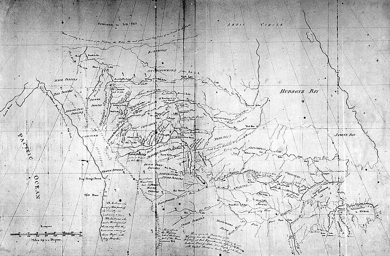
English: Copy of a Map Presented to Congress of United States and to the Lt. Governor of Quebec by Peter Pond, 1785 |
| Date |
29 July 2005 (original upload date) |
| Source |
Transferred from en.wikipedia to Commons. |
| Author | Peter Pond |
| Permission (Reusing this file) |
Public domain per [1] |
Licensing
|
This work is in the public domain in its country of origin and other countries and areas where the copyright term is the author's life plus 100 years or fewer. | |
| This file has been identified as being free of known restrictions under copyright law, including all related and neighboring rights. | |
Original upload log
The original description page was here. All following user names refer to en.wikipedia.
- 2005-07-29 17:56 Carnildo 800×525× (159788 bytes) Reverted to earlier revision
- 2005-07-29 13:43 Mwanner 150×98× (6765 bytes) Reverted to earlier revision
- 2005-07-29 13:41 Mwanner 800×525× (159788 bytes) Reverted to earlier revision
- 2005-07-29 13:39 Mwanner 150×98× (6765 bytes) Reverted to earlier revision
- 2005-07-29 13:38 Mwanner 800×525× (159788 bytes) Map of Athabasca - Peter Pond ---- Copy of a Map Presented to Congress of United States and to the Lt. Governor of Quebec by Peter Pond, 1785 Copyright is expired / Source: this historic document is held by the National Archives of Canada and is in the P
- 2004-04-04 19:57 Benji Franklyn 150×98× (6765 bytes) Map of Athabasca - Peter Pond
File history
Click on a date/time to view the file as it appeared at that time.
| Date/Time | Thumbnail | Dimensions | User | Comment | |
|---|---|---|---|---|---|
| current | 06:19, 12 October 2008 | | 800 × 525 (156 KB) | Aboluay | {{Information |Description={{en|Copy of a Map Presented to Congress of United States and to the Lt. Governor of Quebec by Peter Pond, 1785}} |Source=Transferred from [http://en.wikipedia.org en.wikipedia]<br/> (Original text : ''* National Archives of Can |
File usage
The following pages on the English Wikipedia use this file (pages on other projects are not listed):
Global file usage
The following other wikis use this file:
- Usage on ar.wikipedia.org
- Usage on bg.wikipedia.org
- Usage on ca.wikipedia.org
- Usage on de.wikipedia.org
- Usage on es.wikipedia.org
- Usage on fr.wikipedia.org