
File:Map of Argentina with provinces names en.png
Size of this preview: 362 × 599 pixels. Other resolutions: 145 × 240 pixels | 566 × 936 pixels.
Original file (566 × 936 pixels, file size: 28 KB, MIME type: image/png)
| This is a file from the Wikimedia Commons. Information from its description page there is shown below. Commons is a freely licensed media file repository. You can help. |
Summary
| Description |
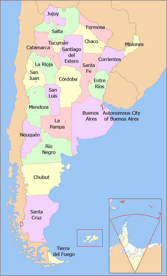
English: Map of the Argentine Provinces with their names in English.
Español: Mapa político de la República Argentina, indicando en inglés el nombre de cada provincia. |
| Date | |
| Source | Own work based on File:Argentina - Político.png |
| Author | Bleff |
| Other versions | Image:Map of Argentina with provinces names en.png |
Licensing
I, the copyright holder of this work, hereby publish it under the following licenses:

|
Permission is granted to copy, distribute and/or modify this document under the terms of the GNU Free Documentation License, Version 1.2 or any later version published by the Free Software Foundation; with no Invariant Sections, no Front-Cover Texts, and no Back-Cover Texts. A copy of the license is included in the section entitled GNU Free Documentation License. |
| This file is licensed under the Creative Commons Attribution-Share Alike 3.0 Unported license. | ||
| ||
| This licensing tag was added to this file as part of the GFDL licensing update. |
You may select the license of your choice.
File history
Click on a date/time to view the file as it appeared at that time.
| Date/Time | Thumbnail | Dimensions | User | Comment | |
|---|---|---|---|---|---|
| current | 15:08, 23 February 2018 | | 566 × 936 (28 KB) | Janitoalevic | Fixed borders |
| 03:54, 29 February 2012 |  | 566 × 936 (48 KB) | Bleff | Bigger letters. | |
| 22:38, 20 August 2011 |  | 566 × 936 (28 KB) | Bleff | == {{int:filedesc}} == {{Information |Description={{en|1=Map of the Argentine Provinces with their names in English.}} {{es|1=Mapa político de la República Argentina, indicando en inglés el nombre de cada provincia.}} |Source={{own}} based on [[:File:A |
File usage
The following pages on the English Wikipedia use this file (pages on other projects are not listed):
Global file usage
The following other wikis use this file:
- Usage on bs.wikipedia.org
- Usage on fa.wikipedia.org
- Usage on id.wikipedia.org
- Usage on io.wikipedia.org
- Usage on it.wikipedia.org
- Usage on pa.wikipedia.org
- Usage on ta.wikipedia.org
- Usage on th.wikipedia.org
- Usage on ur.wikipedia.org