
File:M 6.9 - 86 km SE of Lugu, Taiwan.jpg

Size of this preview: 466 × 599 pixels. Other resolutions: 187 × 240 pixels | 373 × 480 pixels | 597 × 768 pixels | 797 × 1,024 pixels | 1,593 × 2,048 pixels | 4,058 × 5,216 pixels.
Original file (4,058 × 5,216 pixels, file size: 3.39 MB, MIME type: image/jpeg)
| This is a file from the Wikimedia Commons. Information from its description page there is shown below. Commons is a freely licensed media file repository. You can help. |
Summary
| Description |
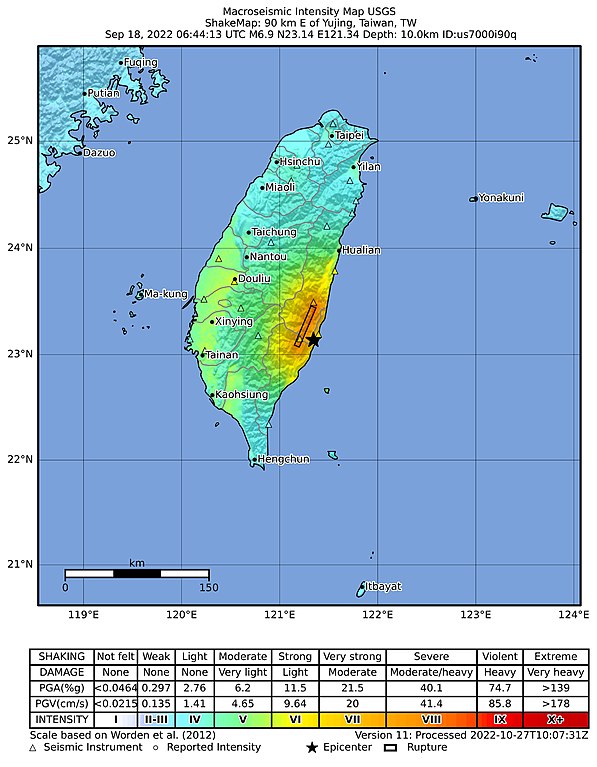
English: USGS ShakeMap of the 2022 Taitung earthquakes M 6.9 mainshock |
| Date | |
| Source | [1] |
| Author | U.S. Geological Survey |
Licensing
This image is in the public domain in the United States because it only contains materials that originally came from the United States Geological Survey, an agency of the United States Department of the Interior. For more information, see the official USGS copyright policy.
|
File history
Click on a date/time to view the file as it appeared at that time.
| Date/Time | Thumbnail | Dimensions | User | Comment | |
|---|---|---|---|---|---|
| current | 16:13, 13 November 2022 | | 4,058 × 5,216 (3.39 MB) | Crannofonix | update |
| 07:00, 16 October 2022 |  | 778 × 1,005 (105 KB) | Dora the Axe-plorer | Uploaded a work by U.S. Geological Survey from [https://earthquake.usgs.gov/earthquakes/eventpage/us7000i90q/shakemap/intensity] with UploadWizard |
File usage
The following pages on the English Wikipedia use this file (pages on other projects are not listed):