
File:Lower Green Bay, February 25, 2022, true color Landsat-8.png

Size of this preview: 593 × 600 pixels. Other resolutions: 237 × 240 pixels | 475 × 480 pixels | 759 × 768 pixels | 1,012 × 1,024 pixels | 2,025 × 2,048 pixels | 7,831 × 7,921 pixels.
Original file (7,831 × 7,921 pixels, file size: 74.69 MB, MIME type: image/png)
| This is a file from the Wikimedia Commons. Information from its description page there is shown below. Commons is a freely licensed media file repository. You can help. |
| Description | ||||
| Date | ||||
| Source | converted to .png by Epiphyllumlover from the original .tif available as item LC09_L1TP_023029_20220225_20220225_02_T1_B2, B3, and B4 on EarthExplorer | |||
| Author | National Oceanic and Atmospheric Administration's Landsat program | |||
| Permission (Reusing this file) |
|
|||
| Other versions |


File history
Click on a date/time to view the file as it appeared at that time.
| Date/Time | Thumbnail | Dimensions | User | Comment | |
|---|---|---|---|---|---|
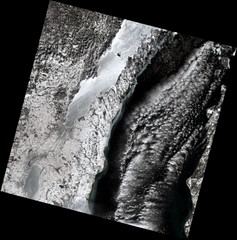
| current | 07:24, 28 March 2022 | | 7,831 × 7,921 (74.69 MB) | Epiphyllumlover | c:User:Rillke/bigChunkedUpload.js: {{Information | Description = {{en|1=Aerial view of the lower w:Green Bay (Lake Michigan) and vincinity on February, 25, 2022. From Landsat-8. }} | Date = 2022-02-25 | Source = converted to .png by Epiphyllumlover from the original .tif available as item LC09_L1TP_023029_20220225_20220225_02_T1_B2, B3, and B4 on [https://earthexplorer.usgs.gov/ EarthExplorer] | Author = Aerial Photography Field... |
File usage
No pages on the English Wikipedia use this file (pages on other projects are not listed).