
File:Lower Egypt 460 BC.png

Size of this preview: 600 × 600 pixels. Other resolutions: 240 × 240 pixels | 480 × 480 pixels | 1,000 × 1,000 pixels.
Original file (1,000 × 1,000 pixels, file size: 188 KB, MIME type: image/png)
| This is a file from the Wikimedia Commons. Information from its description page there is shown below. Commons is a freely licensed media file repository. You can help. |
| Description |
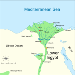
English: Map of Lower Ancient Egypt, showing locations relevant to the Delian league campaign in Egypt, 460–454 BC. |
| Date | (UTC) |
| Source | |
| Author |
|
| This is a retouched picture, which means that it has been digitally altered from its original version. Modifications: Simplified, added one label. The original can be viewed here: Lower Egypt-en.png:
|
I, the copyright holder of this work, hereby publish it under the following licenses:
This file is licensed under the Creative Commons Attribution-Share Alike 3.0 Unported, 2.5 Generic, 2.0 Generic and 1.0 Generic license.
- You are free:
- to share – to copy, distribute and transmit the work
- to remix – to adapt the work
- Under the following conditions:
- attribution – You must give appropriate credit, provide a link to the license, and indicate if changes were made. You may do so in any reasonable manner, but not in any way that suggests the licensor endorses you or your use.
- share alike – If you remix, transform, or build upon the material, you must distribute your contributions under the same or compatible license as the original.

|
Permission is granted to copy, distribute and/or modify this document under the terms of the GNU Free Documentation License, Version 1.2 or any later version published by the Free Software Foundation; with no Invariant Sections, no Front-Cover Texts, and no Back-Cover Texts. A copy of the license is included in the section entitled GNU Free Documentation License. |
You may select the license of your choice.
Original upload log
This image is a derivative work of the following images:
- File:Lower_Egypt-en.png licensed with Cc-by-sa-3.0,2.5,2.0,1.0, GFDL
- 2009-06-29T18:00:53Z MinisterForBadTimes 1000x1000 (197847 Bytes) Hopefully fixed border this time
- 2009-06-29T17:59:06Z MinisterForBadTimes 1000x1000 (197853 Bytes) Moved border
- 2009-06-29T17:57:24Z MinisterForBadTimes 1000x1000 (197891 Bytes) Added border
- 2009-06-29T17:49:58Z MinisterForBadTimes 1000x1000 (194897 Bytes) {{Information |Description={{en|Map of Lower Ancient Egypt, showing the Nile and major cities and sites of the Dynastic period (c. 3150 BC to 30 BC). |Source=*[[:File:Ancient_Egypt_map-en.svg|]] |Date=2009-06-29 18:49 (UTC) |
Uploaded with derivativeFX
File history
Click on a date/time to view the file as it appeared at that time.
| Date/Time | Thumbnail | Dimensions | User | Comment | |
|---|---|---|---|---|---|
| current | 18:15, 29 June 2009 | | 1,000 × 1,000 (188 KB) | MinisterForBadTimes | {{Information |Description={{en|Map of Lower Ancient Egypt, showing locations relevant to the Delian league campaign in Egypt, 460–454 BC.}} |Source=*File:Lower_Egypt-en.png |Date=2009-06-29 19:15 (UTC) |Author=*File:Lower_Egypt-en.png: |
File usage
The following pages on the English Wikipedia use this file (pages on other projects are not listed):
Global file usage
The following other wikis use this file:
- Usage on azb.wikipedia.org
- Usage on el.wikipedia.org
- Usage on es.wikipedia.org
- Usage on hu.wikipedia.org
- Usage on it.wikipedia.org
- Usage on nl.wikipedia.org