
File:Loo Winds India Pakistan Map.jpg
Size of this preview: 448 × 600 pixels. Other resolutions: 179 × 240 pixels | 359 × 480 pixels | 680 × 910 pixels.
Original file (680 × 910 pixels, file size: 144 KB, MIME type: image/jpeg)
| This is a file from the Wikimedia Commons. Information from its description page there is shown below. Commons is a freely licensed media file repository. You can help. |
| Description |
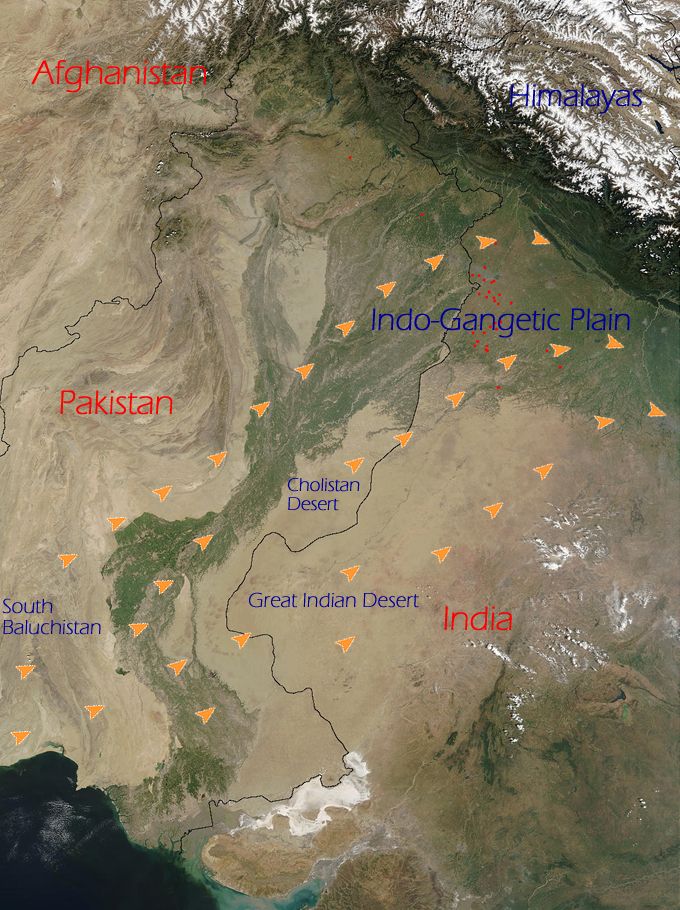
English: The orange arrows indicate how the Loo originates in the deserts of Thar (Great Indian Desert), Cholistan and Baluchistan and flow eastwards towards the entire western part of the Indo-Gangetic plain. |
|||||
| Source | NASA (http://www.visibleearth.nasa.gov/view_rec.php?id=4716) | |||||
| Author | NASA | |||||
| Permission (Reusing this file) |
|

This is derived from an original NASA satellite map modified (by me) to indicate directions of Loo winds. To remove any doubt, I also hereby release any changes added to the original image by me to the public domain. No rights whatsoever are claimed.
File history
Click on a date/time to view the file as it appeared at that time.
| Date/Time | Thumbnail | Dimensions | User | Comment | |
|---|---|---|---|---|---|
| current | 21:21, 20 June 2009 | | 680 × 910 (144 KB) | Hunnjazal | {{Information |Description={{en|1=The orange arrows indicate how the Loo originates in the deserts of Thar (Great Indian Desert), Cholistan and Baluchistan and flow eastwards towards the entire western part of the Indo-Gangetic plain.}} |Source=NASA (http |
File usage
The following pages on the English Wikipedia use this file (pages on other projects are not listed):
Global file usage
The following other wikis use this file:
- Usage on ar.wikipedia.org
- Usage on bh.wikipedia.org
- Usage on bn.wikipedia.org
- Usage on ca.wikipedia.org
- Usage on es.wikipedia.org
- Usage on ml.wikipedia.org
- Usage on nn.wikipedia.org
- Usage on pa.wikipedia.org
- Usage on ru.wikipedia.org
- Usage on uk.wikipedia.org
- Usage on www.wikidata.org