
File:Location map United Kingdom City of Lancaster.svg

Size of this PNG preview of this SVG file: 535 × 600 pixels. Other resolutions: 214 × 240 pixels | 428 × 480 pixels | 685 × 768 pixels | 913 × 1,024 pixels | 1,827 × 2,048 pixels | 1,164 × 1,305 pixels.
Original file (SVG file, nominally 1,164 × 1,305 pixels, file size: 5.03 MB)
| This is a file from the Wikimedia Commons. Information from its description page there is shown below. Commons is a freely licensed media file repository. You can help. |
Summary
| Description |
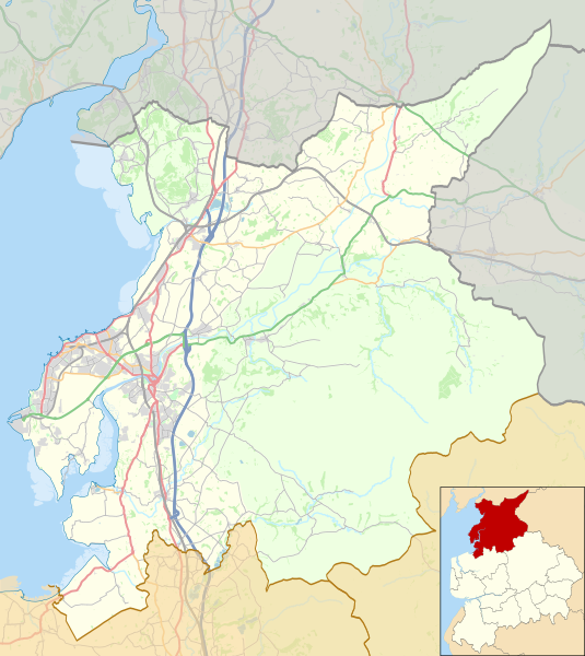
English: Map of the City of Lancaster district, Lancashire, England.
Equirectangular map projection on WGS 84 datum, with N/S stretched 165% Geographic limits:
|
| Date | 22:51, updated 2017-05-03 |
| Source |
This file was derived from: |
| Author |
|
| Other versions |
|

.svg)
Licensing
| This work contains information from OpenStreetMap, which is made available under the Open Database License (ODbL).
The ODbL does not require any particular license for maps produced from ODbL data. Prior to 1 August 2020, map tiles produced by the OpenStreetMap Foundation were licensed under the CC-BY-SA-2.0 license. Maps produced by other people may be subject to other licences. |
This file is licensed under the Creative Commons Attribution-Share Alike 2.0 Generic license.
Attribution: © OpenStreetMap contributors. © Natural England copyright 2012. Contains Ordnance Survey data © Crown copyright and database right 2012.
- You are free:
- to share – to copy, distribute and transmit the work
- to remix – to adapt the work
- Under the following conditions:
- attribution – You must give appropriate credit, provide a link to the license, and indicate if changes were made. You may do so in any reasonable manner, but not in any way that suggests the licensor endorses you or your use.
- share alike – If you remix, transform, or build upon the material, you must distribute your contributions under the same or compatible license as the original.
File history
Click on a date/time to view the file as it appeared at that time.
| Date/Time | Thumbnail | Dimensions | User | Comment | |
|---|---|---|---|---|---|
| current | 21:43, 7 May 2018 | | 1,164 × 1,305 (5.03 MB) | Dr Greg | Some minor colour changes to improve clarity |
| 21:27, 3 May 2017 |  | 1,164 × 1,305 (5.06 MB) | Dr Greg | Added Heysham link road | |
| 22:06, 25 July 2014 |  | 1,164 × 1,305 (5.03 MB) | Dr Greg | User created page with UploadWizard |
File usage
More than 100 pages use this file. The following list shows the first 100 pages that use this file only. A full list is available.
- Abbeystead
- Abbeystead House
- Abraham Heights
- Aldcliffe
- Arkholme-with-Cawood
- Arkholme for Kirkby Lonsdale railway station
- Bailrigg
- Bank Houses
- Bare, Morecambe
- Bare Lane railway station
- Bay Horse
- Bay Horse railway station
- Bolton-le-Sands
- Borwick
- Borwick Hall
- Burrow-with-Burrow
- Cantsfield
- Capernwray Chapel
- Capernwray Hall
- Carnforth
- Carnforth railway station
- Caton-with-Littledale
- Christ Church, Glasson
- Christ Church, Over Wyresdale
- City of Lancaster
- Claughton, Lancaster
- Clougha Pike
- Cockerham
- Cockersand Abbey
- Cowan Bridge
- Dolphinholme
- Ellel, Lancashire
- Escowbeck
- Galgate
- Galgate railway station
- Glasson Dock
- Gragareth
- Great Stone of Fourstones
- Green Hill (Lancashire)
- Gressingham
- Grit Fell
- HM Prison Lancaster Farms
- Halton-with-Aughton
- Halton railway station (Lancashire)
- Hawthornthwaite Fell
- Heaton-with-Oxcliffe
- Heysham
- Heysham Port railway station
- Hornby-with-Farleton
- Hornby Castle, Lancashire
- Hornby Village Institute
- Ireby, Lancashire
- Lancaster, Lancashire
- Lancaster Green Ayre railway station
- Lancaster railway station
- Leck, Lancashire
- Leck Fell
- Leighton Hall, Lancashire
- Leighton Moss RSPB reserve
- Melling-with-Wrayton
- Middleton, Lancashire
- Morecambe
- Morecambe Promenade railway station
- Morecambe railway station
- Nether Burrow
- Nether Kellet
- Over Kellet
- Over Wyresdale
- Overton, Lancashire
- Priest Hutton
- Quernmore
- Roeburndale
- Scotforth
- Silverdale, Lancashire
- Silverdale railway station
- Skerton
- Slyne-with-Hest
- St John the Baptist's Church, Tunstall
- St John the Evangelist's Church, Gressingham
- St Margaret's Church, Hornby
- St Oswald's Church, Warton
- St Peter's Church, Heysham
- St Wilfrid's Church, Melling
- Stodday
- Sunderland, Lancashire
- Tatham, Lancashire
- Tewitfield
- Thurnham, Lancashire
- Torrisholme
- Tunstall, Lancashire
- Ward's Stone
- Warton, Lancaster
- Wennington, Lancashire
- Wennington railway station
- White Hill (Forest of Bowland)
- Whittington, Lancashire
- Wolfhole Crag
- Wray, Lancashire
- Wray-with-Botton
- Yealand Conyers
View more links to this file.
Global file usage
The following other wikis use this file:
- Usage on ar.wikipedia.org
- Usage on azb.wikipedia.org
- Usage on fa.wikipedia.org
- Usage on si.wikipedia.org
- Usage on sk.wikipedia.org
- Usage on zh.wikipedia.org