
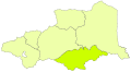
File:Localització de l'Alta Cerdanya als Pirineus Orientals.svg

Size of this PNG preview of this SVG file: 558 × 304 pixels. Other resolutions: 320 × 174 pixels | 640 × 349 pixels | 1,024 × 558 pixels | 1,280 × 697 pixels | 2,560 × 1,395 pixels.
Original file (SVG file, nominally 558 × 304 pixels, file size: 178 KB)
| This is a file from the Wikimedia Commons. Information from its description page there is shown below. Commons is a freely licensed media file repository. You can help. |
Summary
Català: Localització de l'Alta Cerdanya als Pirineus Orientals.
Licensing
This file is licensed under the Creative Commons Attribution-Share Alike 2.5 Generic license.
Attribution: Joan M. Borràs (ebrenc)
- You are free:
- to share – to copy, distribute and transmit the work
- to remix – to adapt the work
- Under the following conditions:
- attribution – You must give appropriate credit, provide a link to the license, and indicate if changes were made. You may do so in any reasonable manner, but not in any way that suggests the licensor endorses you or your use.
- share alike – If you remix, transform, or build upon the material, you must distribute your contributions under the same or compatible license as the original.
See also
-
 Localització de la Fenolleda als Pirineus Orientals.svg
 -
 Localització del Capcir als Pirineus Orientals.svg
 -
 Localització del Conflent als Pirineus Orientals.svg
 -
 Localització del Rosselló als Pirineus Orientals.svg
 -
 Localització del Vallespir als Pirineus Orientals.svg


File history
Click on a date/time to view the file as it appeared at that time.
| Date/Time | Thumbnail | Dimensions | User | Comment | |
|---|---|---|---|---|---|
| current | 21:57, 4 February 2007 | | 558 × 304 (178 KB) | Ebrenc | ==License== {{Cc-by-sa-2.5|Joan M. Borràs (ebrenc)}} Category:Pyrénées-Orientales Category:Maps of comarques of Northern Catalonia |
File usage
The following pages on the English Wikipedia use this file (pages on other projects are not listed):
Global file usage
The following other wikis use this file:
- Usage on an.wikipedia.org
- Usage on br.wikipedia.org
- Usage on ca.wikipedia.org
- Usage on ca.wikiquote.org
- Usage on da.wikipedia.org
- Usage on de.wikipedia.org
- Usage on diq.wikipedia.org
- Usage on eo.wikipedia.org
- Usage on es.wikipedia.org
- Usage on eu.wikipedia.org
- Usage on fr.wikipedia.org
- Usage on oc.wikipedia.org
- Usage on pt.wikipedia.org
- Usage on ro.wikipedia.org
- Usage on ru.wikipedia.org
- Usage on uk.wikipedia.org
- Usage on www.wikidata.org