
File:LLWAS.jpg
No higher resolution available.
LLWAS.jpg (640 × 477 pixels, file size: 30 KB, MIME type: image/jpeg)
| This is a file from the Wikimedia Commons. Information from its description page there is shown below. Commons is a freely licensed media file repository. You can help. |
Summary
| Description |
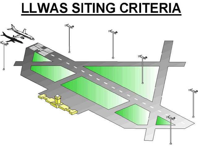
English: Siting of anemometers along a runway for detection of low level wind shears such as microbursts or turbulent crosswinds. |
| Date | |
| Source | National Weather Service Aviation Weather Service Program |
| Author | US Federal Aeronautic Administration (FAA) |
Licensing
This image or file is a work of a Federal Aviation Administration employee, taken or made as part of that person's official duties. As a work of the U.S. federal government, the image is in the public domain in the United States.
|
 |
File history
Click on a date/time to view the file as it appeared at that time.
| Date/Time | Thumbnail | Dimensions | User | Comment | |
|---|---|---|---|---|---|
| current | 23:55, 20 April 2020 | | 640 × 477 (30 KB) | Pierre cb | Uploaded a work by US Federal Aeronautic Administration (FAA) from [https://www.faa.gov/air_traffic/publications/atpubs/aim_html/chap7_section_1.html National Weather Service Aviation Weather Service Program] with UploadWizard |
File usage
The following pages on the English Wikipedia use this file (pages on other projects are not listed):
Global file usage
The following other wikis use this file:
- Usage on fr.wikipedia.org
- Usage on ig.wikipedia.org
- Usage on www.wikidata.org