
File:LIRR map 1876.svg

Size of this PNG preview of this SVG file: 800 × 475 pixels. Other resolutions: 320 × 190 pixels | 640 × 380 pixels | 1,024 × 608 pixels | 1,280 × 760 pixels | 2,560 × 1,520 pixels | 1,152 × 684 pixels.
Original file (SVG file, nominally 1,152 × 684 pixels, file size: 532 KB)
| This is a file from the Wikimedia Commons. Information from its description page there is shown below. Commons is a freely licensed media file repository. You can help. |
Summary
| Description |
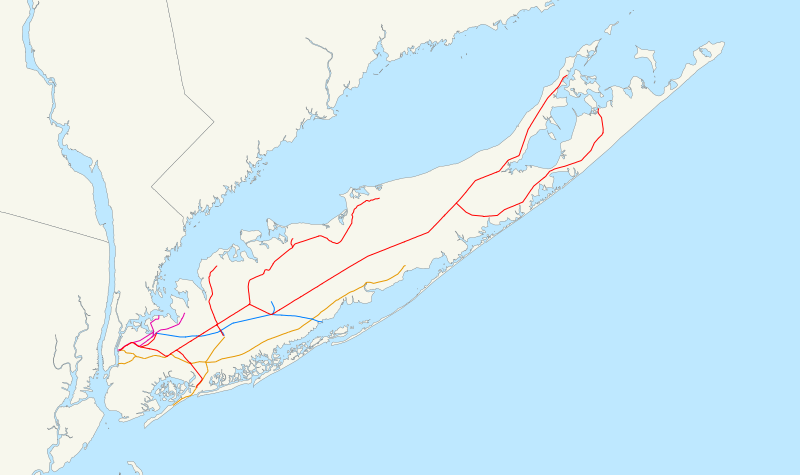
Map of the rail network owned by the Long Island Rail Road in 1876, just after consolidation. The original LIRR is red, the Southern Railroad is orange, the Flushing and North Side Railroad is purple, and the Central Railroad is blue. A standard North American Lambert conformal conic projection was used. |
| Date | |
| Source |
Own work using public domain GIS data:
|
| Author | User:NE2 |
Licensing
| I, the copyright holder of this work, release this work into the public domain. This applies worldwide. In some countries this may not be legally possible; if so: I grant anyone the right to use this work for any purpose, without any conditions, unless such conditions are required by law. |
File history
Click on a date/time to view the file as it appeared at that time.
| Date/Time | Thumbnail | Dimensions | User | Comment | |
|---|---|---|---|---|---|
| current | 05:02, 23 January 2007 | | 1,152 × 684 (532 KB) | NE2 | Darkened the orange. |
| 05:00, 23 January 2007 |  | 1,152 × 684 (532 KB) | NE2 | This is a map of the rail network owned by the Long Island Rail Road in 1876, just after consolidation. The original LIRR is red, the Southern Railroad is orange, the Flushing and North Side Railroad is purple, and the Central Railroad is blue. The follo |
File usage
The following pages on the English Wikipedia use this file (pages on other projects are not listed):