
File:Ktobmap.PNG
No higher resolution available.
Ktobmap.PNG (358 × 420 pixels, file size: 45 KB, MIME type: image/png)
| This is a file from the Wikimedia Commons. Information from its description page there is shown below. Commons is a freely licensed media file repository. You can help. |
Summary
| Description |
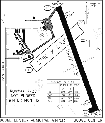
English: The airport diagram for Dodge Center Airport |
| Date | 02:49, 27 July 2011 (UTC) |
| Source | FAA/MnDot |
| Author | FAA |
Licensing
| This image is a work of a United States Department of Transportation employee, taken or made as part of that person's official duties. As a work of the U.S. federal government, the image is in the public domain. |
File history
Click on a date/time to view the file as it appeared at that time.
| Date/Time | Thumbnail | Dimensions | User | Comment | |
|---|---|---|---|---|---|
| current | 02:49, 27 July 2011 | | 358 × 420 (45 KB) | Tornado9989 | {{Information |Description = The airport diagram for Dodge Center Airport |Source = FAA/MnDot |Date = ~~~~~ |Author = FAA |Permission = |other_versions = }} |
File usage
The following pages on the English Wikipedia use this file (pages on other projects are not listed):
Global file usage
The following other wikis use this file:
- Usage on ur.wikipedia.org