
File:Karte Deutsches Reich, Gliederung der oberen Verwaltungsebenen 1900-01-01.png

Size of this preview: 713 × 599 pixels. Other resolutions: 286 × 240 pixels | 571 × 480 pixels | 914 × 768 pixels | 1,218 × 1,024 pixels | 2,486 × 2,090 pixels.
Original file (2,486 × 2,090 pixels, file size: 796 KB, MIME type: image/png)
| This is a file from the Wikimedia Commons. Information from its description page there is shown below. Commons is a freely licensed media file repository. You can help. |
Summary
| Description |
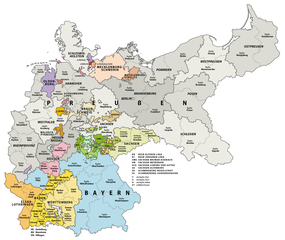
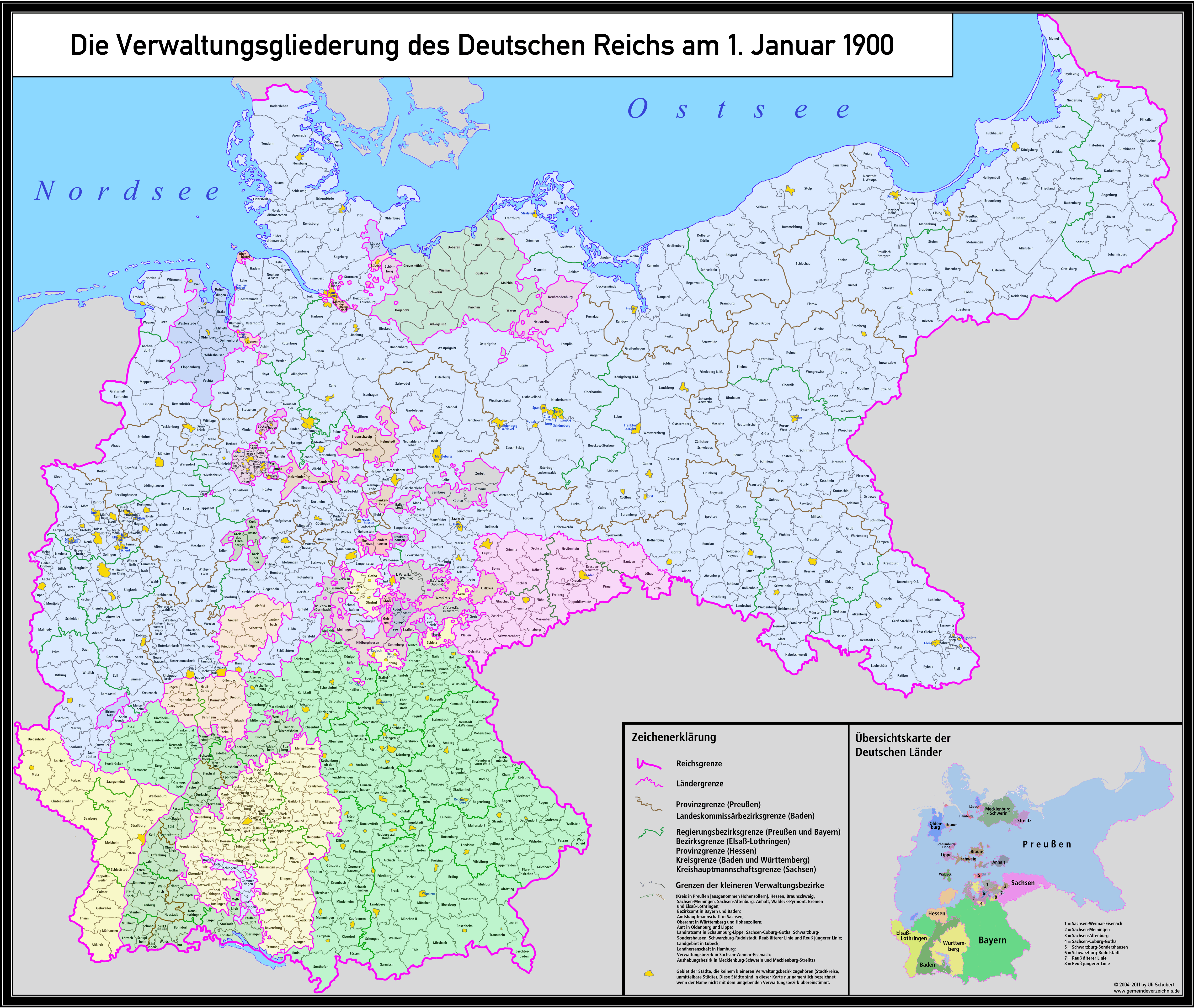
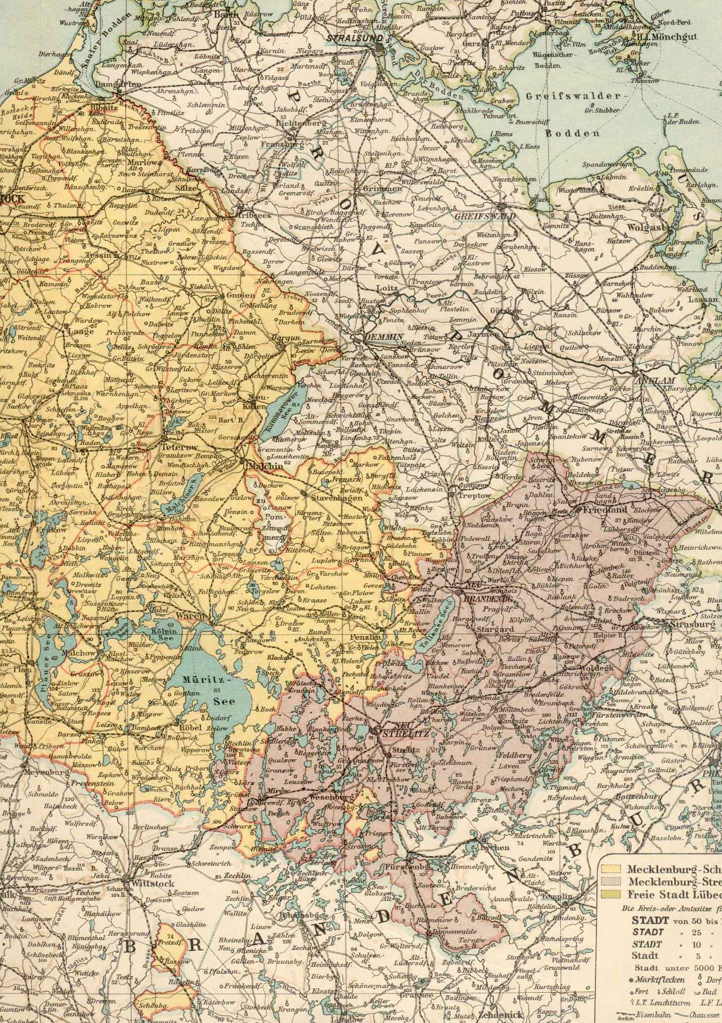
Deutsch: Karte der Verwaltungsgliederung des Deutschen Reichs zum Stand 1. Januar 1900
English: Administrative Map of the German Empire as of January 1st, 1900 |
| Date | |
| Source |
Own work, using following data and information:
...and many more maps and information from diverse Wikipedia articles.
|
| Author | Maximilian Dörrbecker (Chumwa) |
| Permission (Reusing this file) |
This file is licensed under the Creative Commons Attribution-Share Alike 2.0 Generic license.
Sie dürfen das Bild zu den folgenden Bedingungen nutzen:
|
| Other versions |
|


.svg)
.jpg)
File history
Click on a date/time to view the file as it appeared at that time.
| Date/Time | Thumbnail | Dimensions | User | Comment | |
|---|---|---|---|---|---|
| current | 08:09, 15 August 2017 | | 2,486 × 2,090 (796 KB) | Chumwa | Aurich war am 1.1.1900 ein eigener Regierungsbezirk in der preußischen Provinz Hannover |
| 17:52, 21 July 2015 |  | 2,486 × 2,090 (801 KB) | Chumwa | == {{int:filedesc}} == {{Information |Description = {{de|1=Karte der Verwaltungsgliederung des Deutschen Reichs zum Stand 1. Januar 1900}} {{en|1=Administrative Map of the German Empire as of January 1st, 1900}} |Source={{own}}, using following data... |
File usage
The following pages on the English Wikipedia use this file (pages on other projects are not listed):
Global file usage
The following other wikis use this file:
- Usage on azb.wikipedia.org
- Usage on de.wikipedia.org
- Usage on el.wikipedia.org
- Usage on et.wikipedia.org
- Usage on no.wikipedia.org
- Usage on uk.wikipedia.org
- Usage on vi.wikipedia.org
- Usage on www.wikidata.org