
File:Karte - Kesselschlacht bei Vjasma 1941.png

Size of this preview: 583 × 600 pixels. Other resolutions: 233 × 240 pixels | 467 × 480 pixels | 747 × 768 pixels | 1,047 × 1,077 pixels.
Original file (1,047 × 1,077 pixels, file size: 338 KB, MIME type: image/png)
| This is a file from the Wikimedia Commons. Information from its description page there is shown below. Commons is a freely licensed media file repository. You can help. |
Summary
| Description |
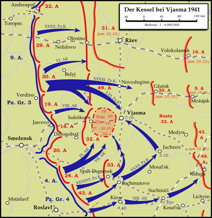
English: Map showing the Battle near Vyazma (October 2nd — October 20th 1941) during the Second World War (1939—1945) at the Eastern Front. The map is created by Inkscape and is based on the Map 30 in the attachement of the book P.N. Pospelow (Hrsg.): Geschichte des Großen Vaterländischen Krieges der Sowjetunion, Bd.2, Berlin (Ost) 1963. The troop movements have been corrected.
Deutsch: Karte der Kesselschlacht im Raum Vjasma (2. Oktober — 20. Oktober 1941) während des Zweiten Weltkrieges (1939—1945) an der Ostfront. Die Karte wurde mit Inkscape erstellt und basiert auf Karte Nr.30 aus dem Anhang des Buches P.N. Pospelow (Hrsg.): Geschichte des Großen Vaterländischen Krieges der Sowjetunion, Bd.2, Berlin (Ost) 1963. Die Truppenbewegungen wurden jedoch korrigiert. |
| Date | |
| Source | Own work |
| Author | Memnon335bc |
Licensing
I, the copyright holder of this work, hereby publish it under the following licenses:
This file is licensed under the Creative Commons Attribution-Share Alike 3.0 Unported license.
- You are free:
- to share – to copy, distribute and transmit the work
- to remix – to adapt the work
- Under the following conditions:
- attribution – You must give appropriate credit, provide a link to the license, and indicate if changes were made. You may do so in any reasonable manner, but not in any way that suggests the licensor endorses you or your use.
- share alike – If you remix, transform, or build upon the material, you must distribute your contributions under the same or compatible license as the original.

|
Permission is granted to copy, distribute and/or modify this document under the terms of the GNU Free Documentation License, Version 1.2 or any later version published by the Free Software Foundation; with no Invariant Sections, no Front-Cover Texts, and no Back-Cover Texts. A copy of the license is included in the section entitled GNU Free Documentation License. |
You may select the license of your choice.
File history
Click on a date/time to view the file as it appeared at that time.
| Date/Time | Thumbnail | Dimensions | User | Comment | |
|---|---|---|---|---|---|
| current | 22:19, 13 January 2024 | | 1,047 × 1,077 (338 KB) | Андрей Романенко | some names and locations corrected |
| 22:01, 31 May 2015 |  | 1,047 × 1,077 (333 KB) | Cmdrjameson | Compressed with pngout. Reduced by 140kB (29% decrease). | |
| 22:53, 13 September 2009 |  | 1,047 × 1,077 (474 KB) | Memnon335bc | {{Information |Description={{en|1=Map showing the Battle near Vyazma (October 2nd — October 20th 1941) during the Second World War (1939—1945) at the Eastern Front. The map is created by Inkscape and is based on the Map 30 in the attachement of the bo |
File usage
The following pages on the English Wikipedia use this file (pages on other projects are not listed):
Global file usage
The following other wikis use this file:
- Usage on bg.wikipedia.org
- Usage on de.wikipedia.org
- Usage on et.wikipedia.org
- Usage on fa.wikipedia.org
- Usage on fi.wikipedia.org
- Usage on he.wikipedia.org
- Usage on it.wikipedia.org
- Usage on mn.wikipedia.org
- Usage on nl.wikipedia.org
- Usage on ru.wikipedia.org
- Usage on tr.wikipedia.org
- Usage on uk.wikipedia.org
- Usage on vi.wikipedia.org
- Usage on www.wikidata.org
- Usage on zh.wikipedia.org