
File:KBFL Airport Diagram.svg

Size of this PNG preview of this SVG file: 390 × 599 pixels. Other resolutions: 156 × 240 pixels | 313 × 480 pixels | 500 × 768 pixels | 667 × 1,024 pixels | 1,334 × 2,048 pixels | 516 × 792 pixels.
Original file (SVG file, nominally 516 × 792 pixels, file size: 599 KB)
| This is a file from the Wikimedia Commons. Information from its description page there is shown below. Commons is a freely licensed media file repository. You can help. |
Summary
| Description |
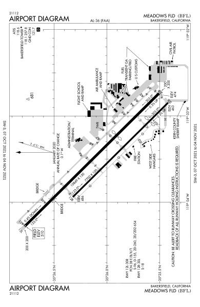
English: Airport diagram for Meadows Field Airport (BFL)
Español: Diagrama de aeropuerto para el aeropuerto Meadows Field (BFL)
Deutsch: Flughafendiagramm für den Flughafen Meadows Field (BFL) |
| Date | |
| Source | https://aeronav.faa.gov/d-tpp/2110/00036AD.PDF |
| Author | Federal Aviation Administration |
Licensing
This image or file is a work of a Federal Aviation Administration employee, taken or made as part of that person's official duties. As a work of the U.S. federal government, the image is in the public domain in the United States.
|
 |
File history
Click on a date/time to view the file as it appeared at that time.
| Date/Time | Thumbnail | Dimensions | User | Comment | |
|---|---|---|---|---|---|
| current | 21:29, 3 November 2021 | | 516 × 792 (599 KB) | KDTW Flyer | Uploaded own work with UploadWizard |
File usage
The following pages on the English Wikipedia use this file (pages on other projects are not listed):
Global file usage
The following other wikis use this file:
- Usage on es.wikipedia.org
- Usage on www.wikidata.org