
File:June 23-24, 2016, West Virginia rainfall.png

Size of this preview: 800 × 450 pixels. Other resolutions: 320 × 180 pixels | 640 × 360 pixels | 1,024 × 576 pixels | 1,280 × 720 pixels | 2,560 × 1,440 pixels | 4,000 × 2,250 pixels.
Original file (4,000 × 2,250 pixels, file size: 1.97 MB, MIME type: image/png)
| This is a file from the Wikimedia Commons. Information from its description page there is shown below. Commons is a freely licensed media file repository. You can help. |
Summary
| Description |
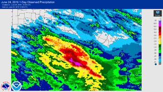
English: This graphic shows the rainfall between from 12:00 UTC to 12:00 UTC June 23 to 24, 2016, across West Virginia. The torrential rains on this day resulted in the state's deadliest flood event since 1985. |
| Date | |
| Source | http://water.weather.gov/precip/ |
| Author | Advanced Hydrologic Prediction Service |
Licensing
This image is in the public domain because it contains materials that originally came from the U.S. National Oceanic and Atmospheric Administration, taken or made as part of an employee's official duties.
|
File history
Click on a date/time to view the file as it appeared at that time.
| Date/Time | Thumbnail | Dimensions | User | Comment | |
|---|---|---|---|---|---|
| current | 23:33, 25 June 2016 | | 4,000 × 2,250 (1.97 MB) | Cyclonebiskit | {{Information |Description={{en|1=This graphic shows the rainfall between from 12:00 UTC to 12:00 UTC June 23 to 24, 2016, across West Virginia. The torrential rains on this day resulted in the state's deadliest flood event since 1985.}} |Source=http:/... |
File usage
The following pages on the English Wikipedia use this file (pages on other projects are not listed):
Global file usage
The following other wikis use this file:
- Usage on ar.wikipedia.org
- Usage on fa.wikipedia.org
- Usage on fr.wikipedia.org
- Usage on ru.wikipedia.org
- Usage on uk.wikipedia.org