
File:John Norden's Map of Westminster - Charing Cross.jpg
No higher resolution available.
John_Norden's_Map_of_Westminster_-_Charing_Cross.jpg (473 × 378 pixels, file size: 154 KB, MIME type: image/jpeg)
| This is a file from the Wikimedia Commons. Information from its description page there is shown below. Commons is a freely licensed media file repository. You can help. |
Summary
| Description |
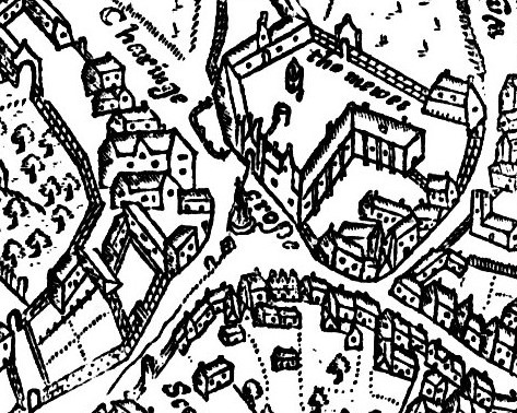
English: John Norden's Map of Westminster, 1593, engraved by Pieter Van den Keere. Original size 9.5 x 6.75 inches, published in Norden's "Middlesex", dated 1593. Norden was born c. 1548, and was made Surveyor of His Majesty's Woods in 1609. Detail of Charing Cross and surrounding area. The map is oriented with north-west to the top: Whitehall is to the bottom left, and the Strand to the bottom right. |
| Date | |
| Source | File:John Norden's Map of Westminster Large version.jpeg |
| Author | John Norden, 1593 |
Licensing
|
This work is in the public domain in its country of origin and other countries and areas where the copyright term is the author's life plus 70 years or fewer. This work is in the public domain in the United States because it was published (or registered with the U.S. Copyright Office) before January 1, 1929. | |
| This file has been identified as being free of known restrictions under copyright law, including all related and neighboring rights. | |
File history
Click on a date/time to view the file as it appeared at that time.
| Date/Time | Thumbnail | Dimensions | User | Comment | |
|---|---|---|---|---|---|
| current | 20:16, 14 June 2019 | | 473 × 378 (154 KB) | GrindtXX | User created page with UploadWizard |
File usage
The following pages on the English Wikipedia use this file (pages on other projects are not listed):
Global file usage
The following other wikis use this file:
- Usage on de.wikipedia.org
- Usage on es.wikipedia.org
- Usage on nl.wikipedia.org