
File:Indian state governments led by various political parties.png

Size of this preview: 514 × 600 pixels. Other resolutions: 206 × 240 pixels | 411 × 480 pixels | 658 × 768 pixels | 877 × 1,024 pixels | 1,486 × 1,734 pixels.
Original file (1,486 × 1,734 pixels, file size: 318 KB, MIME type: image/png)
| This is a file from the Wikimedia Commons. Information from its description page there is shown below. Commons is a freely licensed media file repository. You can help. |
Summary
| Description |
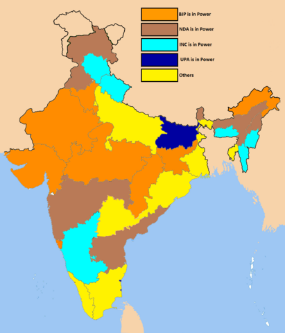
English: The image shows the various states of India along with their respective sate governments led by various political parties and alliances. |
| Date | |
| Source | I downloaded an outdated version of this map and made the corrections to keep it updated with the current political scenario in India. |
| Author | Rahulmdinesh |
Licensing
I, the copyright holder of this work, hereby publish it under the following licenses:

|
Permission is granted to copy, distribute and/or modify this document under the terms of the GNU Free Documentation License, Version 1.2 or any later version published by the Free Software Foundation; with no Invariant Sections, no Front-Cover Texts, and no Back-Cover Texts. A copy of the license is included in the section entitled GNU Free Documentation License. |
This file is licensed under the Creative Commons Attribution-Share Alike 4.0 International license.
- You are free:
- to share – to copy, distribute and transmit the work
- to remix – to adapt the work
- Under the following conditions:
- attribution – You must give appropriate credit, provide a link to the license, and indicate if changes were made. You may do so in any reasonable manner, but not in any way that suggests the licensor endorses you or your use.
- share alike – If you remix, transform, or build upon the material, you must distribute your contributions under the same or compatible license as the original.
You may select the license of your choice.
File history
Click on a date/time to view the file as it appeared at that time.
| Date/Time | Thumbnail | Dimensions | User | Comment | |
|---|---|---|---|---|---|
| current | 19:05, 3 January 2017 | | 1,486 × 1,734 (318 KB) | Nizil Shah | Arunachal Pradesh now ruled by BJP |
| 10:19, 2 June 2016 |  | 1,486 × 1,734 (270 KB) | Poems of borns | better distinguishable colors, esp in articles where pic is smaller | |
| 18:43, 25 May 2016 |  | 1,486 × 1,734 (205 KB) | Poems of borns | Reverted to version as of 05:43, 25 May 2016 (UTC) wrong kashmir map | |
| 06:04, 25 May 2016 |  | 1,486 × 1,734 (204 KB) | Rahulmdinesh | J&K | |
| 05:43, 25 May 2016 |  | 1,486 × 1,734 (205 KB) | Rahulmdinesh | Added Sikkim to the NDA as the ruling Sikkim Democratic Front joined the North East Democratic Alliance which is spearheaded by the NDA (National Democratic alliance). | |
| 05:27, 25 May 2016 |  | 1,486 × 1,734 (205 KB) | Rahulmdinesh | Changed the color of the state of Nagaland to dark orange. | |
| 09:01, 23 May 2016 |  | 1,486 × 1,734 (206 KB) | Rahulmdinesh | {{subst:Upload marker added by en.wp UW}} {{Information |Description = {{en|The image shows the various states of India along with their respective sate governments led by various political parties and alliances. }} |Source = I downloaded an outdated v... |
File usage
No pages on the English Wikipedia use this file (pages on other projects are not listed).
Global file usage
The following other wikis use this file:
- Usage on azb.wikipedia.org
- Usage on ca.wikipedia.org
- Usage on fa.wikipedia.org
- Usage on id.wikipedia.org
- Usage on it.wikipedia.org
- Usage on kn.wikipedia.org
- Usage on ru.wikipedia.org
- Usage on sa.wikipedia.org